LARA State
Geopolitical division
The territory of Lara was occupied by
several indigenous groups, highlighting
the caquetíos, those
jirajaras and the gayones, seated mainly
in the Tocuyo; while the axaguas and
those
achaguas was located in the current
municipality Towers. During the colonial
period and it leaves of the one independentista,
these lands belonged to the County of
Caracas. In 1824 they were part
of the County of Carabobo. In 1832 you
creó the County of Barquisimeto. In
1881 the one is believed
Great North State of West, the one which
later passed to call himself state Lara.
In 1909 the one
Lara acquires its autonomy. It is
divided in nine municipalities and fifty
two parishes.
MAP VIAL
The road of more important terrestrial
communication is the troncal 4 that
crosses the north entity to
south for their end this and it
communicates to the state with Falcon
and Portuguese. Among the populations more
important they highlight: Quíbor,
Cabudare, Carora, Dyer, Cubiro, The
Tocuyo, I will Heal and Siquisique.
Basic DATA
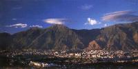
Capital
Barquisimeto.
Location
Region Center–Western.
Limits
North: Falcon.
South: Trujillo and Portuguese.
This: Yaracuy and Cojedes.
West: Trujillo and Zulia.
Surface
19 800 km2.
Percentage of the national territory
2,10%. it is the tenth first entity with
bigger surface of the country.
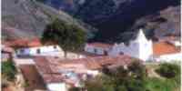
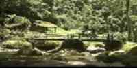
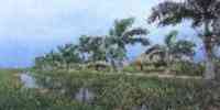
TOURISM
It possesses a single natural monument,
Hill of León, refuge of endemic species
and in danger
of extinction. In Barquisimeto she/he is
the only railroad of passengers of the
country that
it connects to the capital with Puerto
Cabello, Acarigua and San Felipe. The
Center is also erected
Historical Larense with archaeological
and artistic exhibitions, and the Museum
of Barquisimeto.
They highlight three parks: Forest
Macuto, Parque Ayacucho and Parque
Bararida. The Square of the one Shaft
is one of the symbols of the city. Lara
is a state of artisans; the adults
exhibition towns and sale of pieces are:
Dyer, Cubiro, I will Heal and Carora. In
Cubiro you
they locate The Hills of Cubiro, where
the barquisimetanos usually spends a day
of field. In
Duaca is the Spa The Guape and a
petroglifos area. In Quíbor she/he is
the Museum
Archaeological of Quíbor and the
Indigenous Cemetery, both show before
Columbus pieces
pickups in the area. In The Tocuyo the
church of Our should be visited Mrs. of
the
Concepción that has an unique
altarpiece in their style that dates of
1770, as well as the Museum
Historical Lisandro Alvarado, with works
of the famous tocuyense.
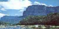
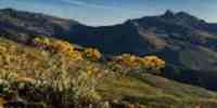
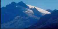
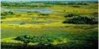
Geography
Geology
It presents a landscape of contrasts:
raised mountainous fronts with
formations of the eras
secondary and tertiary, as well as
alluvial plains of the quaternary era.
The silts
third foldings in anticlinales are
appreciated in lengthened serranías and
parallel to each other. Those silts
of the third superior fewer consolidated
are and they are represented in low
hills
rounded. The valleys and depressions
understand important extensions of silts
of the quaternary one old and recent.
Relief
It is constituted by mountainous
landscapes of hills, valleys and
depressions. The systems
present they are: Andean system:
integrated by the last estribaciones of
the System of those
Walk Venezuelans. The biggest height is
the moor Cendé with 3 585 m.s.n.m.
Sistema Coriano
or Falconiano: formed by the mountains
of Baragua, Bobare-Matatere and
Jirajara-Ziruna; their height maxim
is the hill The Cerrón with 1 900
m.s.n.m. System of the Costa: it
concludes or she/he begins with the
Sierra of Aroa that penetrates for the
center-oriental end, reaching a maximum
height of 2 500 m.s.n.m., in the
hill Stick of Water. The Depression of
Lara is in their central part, with a great
percentage of plane land; besides the
depressions Cloudy-Yaracuy and that of
Moroturo.
Climate
They can be recognized: humid
paramero that corresponds to 0,3% of the
territory, the montano
under humid that represents 4,5%, the
humid premontano with 19% of the
surface, the one
dry and very dry premontano that occupy
30% of the total, and the tropical one
dry and very dry that they occupy
46,2% of the total surface, being the
most representative in the state.
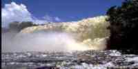
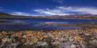
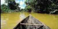
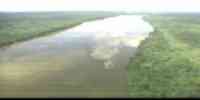
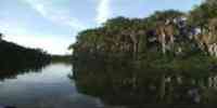
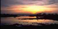
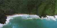
Hydrography
The net hidrográfica is represented
by the basins of the rivers: Cloudy,
Morene, Yacambú,
Sarare and Tocuyo, this last one is the
most important; Cendé is born in the
proximities of the moor and it
crosses the whole territory estadal. In
him they are the reservoirs: Two Hills
and Atarigua.
Other rivers of relevance are: Yellow,
Auro, Baragua, Curarigua and Urama. The
state presents
shortage of the resource dilutes. The
resources hídricos concentrates to the
south and these drenan toward other
entities, except for those that have
their origin in the basin of the river
Tocuyo.
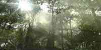
Vegetation
In the part center-north the
vegetation xerófila prevails, abundant
in cujíes, tunas and
cardones. To the south the variation
goes from heaths to forests tropical
subhúmedos. The
forest potential is limited, because the
formations boscosas completes functions
protectors.
They highlight the species: cují, naked
Indian, jabillo, jobo, olive tree,
semeruco and she/he will see.
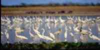
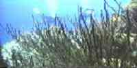
Fauna
It is known about a great variety of
species, such as: rabbits, limpets,
partridges, deer,
doves, and snakes like bell and velvet.
Mineral resources
It not has mineral resources
metallic, especially red clays, white
clays,
sands silíceas, gravels, and several
limestone types. Besides iron, mercury
and pirrofilitas.
Population
According to the XII General Census of
Population and Housing 1990 the
population is of 1 193 161 hab., being
placed in the fifth place with regard to
the national total. It possesses a
populational density of 60,3
hab/km2, three times the national
average. The main urban centers are:
Barquisimeto, Carora, Cubiro, Quíbor,
The Tocuyo, Cabudare and Duaca. The
economic impulse,
generated by the commercial, financial
and industrial activities, it has
motivated a dynamism
demographic that places it like one of
population's main entities receptoras of
the one
country, being their superior indexes of
growth to the national average. As for
the
the population's distribution, one has
that 52,3% is concentrated on the city
of
Barquisimeto.
NATIONAL PARKS
It has five national parks: Terepaima,
to the southeast of Barquisimeto, in the
end
oriental of the Andean Mountain range.
The Guache, in the south side of the
Parque Yacambú, where
they are adjacent the states Lara and
Portuguese. Yacambú, to the southeast
of the state, in the region center - western.
Dinira, in the fork of the valleys:
Soap, Badilla, Aranda and Clubs. Hill
Saroche, in the center-western part.
Economic ACTIVITIES
The main economic activities are:
commercial, financial, industrial and
agricultural. Among
the agricultural items, it is the only
one that produces a considerable
quantity of sisal. It occupies the one first
place in the pineapple production,
cucumber, onion and paprika. Also, it is
the second
producing of coffee, melon, grape and
cane of sugar of the country, and the
third in potato. As for the cattle
raising, is the first producing of
having won caprino and the second in
ovino. As for the sector industrial,
it has important companies of: I cement,
nutritious products, drinks
alcoholic and gassy, steel products and
metalmecánicos, useful and tackle,
lines and
sacks, and musical instruments.
TRADITIONS
Among the varied traditions of Lara, it
highlights the Tamunangue or Dance of
the Black ones of San
Antonio. The party is carried out in
honor to San Antonio of Padua. When
concluding the religious service, the
saint's image is taken out of the
church, followed by the musicians and
the members of the brotherhood.
Then the ceremonial begins. First, Save
Her and the Battle. In the first one you
they recite sentences and it is sung The
it Saves in a journey that visits altars
in the houses of
members of the brotherhood already
deceaseds. In second o'clock, she/he
puts on in scene a dance mockery of
fight of garrotes. Then, the procession
returns to the church, where an altar is
improvised for San Antonio. Then
the celebration of the dance begins that
consists of seven stages or sones:
The Beautiful one, The Yiyivamos, the
Juruminga, The Perrendenga, The little
by little, The Galerón and the one Six
Corrío. Each one with a game
choreographic matter that she/he goes
from the simulation of forms of
courtship, going by burlesque cartoons
of relationships of power among the
couple, until complex figures
intertwined among three couples. The
music is executed with a drum
similar to the cumaco, maracas and rope
instruments as the four and the six cordófono.


 Eco-Portal
Wildlife Venezuela
Eco-Portal
Wildlife Venezuela 