Bolivar
Geopolitical division
In 1777 it was part of the General Captaincy of
Venezuela. In 1856 separates the Territory
Federal Amazons. In 1864 the County of Guayana passes to
call himself state Guayana. In
1881 taking the name of Great Estado Bolívar. Starting
from 1901 it is denominated state Bolivar. You
it divides in ten municipalities and forty parishes.
MAP VIAL
The freeway arrives until Upata, uniting to Ciudad Bolívar,
Ciudad Guayana, Puerto Ordaz and
San Félix. Toward the south a highway takes to
Guasipati, Tumeremo, The Callao, The Gilding and Those White.
Crossing the Solid Guianese a highway leads to Santa
Elena of Uairén and to
Brazil. Other key roads are that of Caicara from the
Orinoco to the west and that of The Paragua and The
Manteco, toward the south.
Basic DATA
Capital
City Bolivar.
Location
Region of Guayana.
Limits
North: Guárico, Anzoátegui, Monagas and Delta Amacuro.
South: Brazil and Amazons.
This: Guayana Esequiba and Brazil.
West: Hurry.
Surface
240 528 km2.
Percentage of the national territory:
26,24%. it is the entity with bigger surface of the
country.
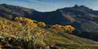
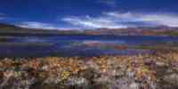
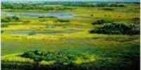
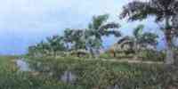
TOURISM
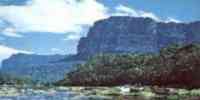
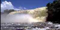
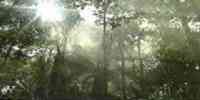
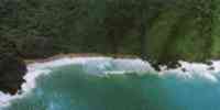
It highlights in The Great Savanna the Formation of
Tepuyes that goes from the western riverside of
the one river Orinoco until the limits with Guayana
Esequiba and Brazil. This natural monument contains more
than a hundred tepuyes. The flora includes dwarf forests
that don't overcome the 10 meters high, devouring
vegetable species, and mortal insects as the ant 24.
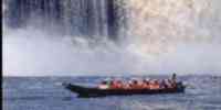
Here they are
the gulches: of Jaspey Pacheco, and the jumps: Aponwao,
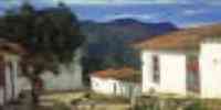
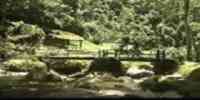
Ángel, the Toad and Kamá. In City
Bolivar the historical helmet that still maintains the
prints of the geste libertadora, the House is
San Isidro, where Bolivar wrote its Speech of
Narrowness, the Museo Etnológico, the Museum of
Modern art Jesús Soto, Ciudad Bolivar's Museum or
Marries of the Mail of the Orinoco where you
it published the first newspaper of Venezuela, the
Outpost The Zamuro and the Paseo Orinoco with the
Mirador of Narrowness. The spas are in Caicara of
the Orinoco: Castillero and Maniapure. In Port Ordaz,
Raúl Leoni Dams it. In San Félix, the parks:
Bicentennial, Cachamay, Loefling, The
It sprinkles and The Christmas. In City to Tweet, the
petroglifos: Cave The Conejero and Cave of the Elephant. And
the mines of the Cerro Bolívar.
Geography
Geology
The geologic basement constitutes it the Guianese
Shield, of great tectonic stability, with
characteristic fisiográficas sui géneris, presenting
varied and complex relief forms,
with prevalence of alteration plains, elevations
denominated tepuyes and other forms
geologic of particular specificity. This solid
mountainous squatter almost the whole territory of
the entity. The half altitude is of 400 m.s.n.m., with a
south decline to north. It presents great
variety of geologic formations that group in four big
counties: Imataca to the one
north, The Shepherdess in the center-oriental part,
Cuchivero in the center-occident and Roraima to the
south.
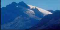
Relief
The relief is varied, with heights that oscillate
between the 200 and 500 m.s.n.m., in the riverbanks of
the one river Orinoco, until the tepuyes of sharp
and abrupt walls, with elevations that overcome
the 2 800 m.s.n.m. In the southeast meets the
mount Roraima with 2 810 m.s.n.m. that serves
of border vertex among Venezuela, Brazil and the Area in
Reclamation. To the south, the mountains of Maigualida,
Aribana, Uaninama and Pacaraima. In The Great Savanna
the relief is formed for
high isolated tables, separated to each other by deep
pipes; highlighting the Sierra of Motto and
the Auyantepuy, where is the Jump Ángel. To the
north the flat lands are located and to the one
northeast the Sierra of Imataca.
Climate
The temperature average is from 26° to 28 °C. Trade
winds of the northeast prevail during the one
period of rain and in trade dry season of the southeast.
The pluviosidad is high and variable, and
they are bigger in reason of the high temperatures than
they cause a strong evaporation,
arriving to the 1 022 mm, annual in Ciudad Bolívar,
while in Maripa it ascends at 1 875 mm.
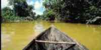
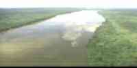
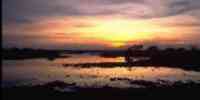
Hydrography
It is conformed by seven main basins whose rivers
present an enormous flow and
numerous jumps, highlighting the rivers: Orinoco (half
basin and it lowers), Cuyuní (high basin and
mediates), Caroní-Paragua, Caura, Hoop,
Cuchivero, Parguaza, Guaniamo and Guaiquinima. The
system hidrográfico is divided in two slopes: the one
integrated by the rivers that end in the one
Orinoco, and those that take their waters to the Cuyuní.
concentrates the biggest reservation national hídrica. Among
the streams they highlight: Arutani and Suapure. It has
a great potential hidroenergético, which satisfies
84,5% of the national consumption, generated for you dam
them Raúl Leoni, Macagua I and Macagua II.
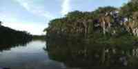
Vegetation
Gallery forests and morichales are observed in the
riversides of the rivers that cross those
savannas. In the tepuyes the cloudy forests prevail. In
the summits of superior heights
to the 1 000 m.s.n.m., the savannas prevail. To the
south the vegetation is of rainy forest or
hydrophilic megatérmica, where plants climbers and
epifitas are plentiful. This formation is very
dense, the trees are so high that they can reach the 40
meters. 6 639 have been inventoried
598 hectares of lands, representing 28% of the surface
estadal, of those which 3 451
239 have. they are susceptible of taking advantage for
agricultural activities.
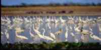
Fauna
212 species of mammals have been reported; 1 108 of
birds, 133 of reptiles, besides 140
amphibians.
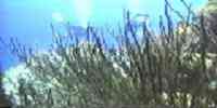
In the basin of the river Orinoco 320 species and
subspecieses of fish exist; 8% of these
they correspond fish of commercial consumption, as:
curvinata, golden, palometa and zapoara.
Mineral resources
They are in the Guianese Shield. They are expressed in
iron reservations and of bauxite, pleasures
auriferous, diamonds, manganese, kaolin, dolomita,
titanium, aluminum, manganese and quartz. Those
locations are located in the hill Bolivar; the
auriferous pleasures in The Callao; and the reservations
of bauxite in Upata, Nuria, and the serranías The
Guaicas and The Pijiguaos.
Population
According to figures of the XII General Census of
Population and Housing, Bolivar concentrated one
population of 900 310 hab, being located in the seventh
place with regard to the national total; the
populational density is of 3,8 hab/km2, very below the
national average. In the last ones
three decades it has presented a quite high relative
growth: 83,41% for 1971;
70,74% for 1981 and 34,7 for 1990. This eats consequence
of the economic impulse
generated by the miner-industrial activity. The
population concentrates on the municipalities Caroní
(51,73%), Heres (25,55%) and to Tweet (8,25%).
The population's evolution is related with the
development of the basic industries,
especially those of the iron, aluminum and electricity,
that which one of the balances generates
migratory more high of the country, directed toward the
municipality Caroní. Besides City
Guayana, highlights other urban centers as: Caicara of
the Orinoco, Tumeremo, Guasipati and
City Bolivar, this last one was the most important until
the development of the industrial activity
in Ciudad Guayana. In this region they settle different
ethnic groups: pemones, kariñas and
yekuanas.
NATIONAL PARKS
It has two national parks: Canaima, located in the
Guianese Shield, to the Southwest of the one
state, in the birth of the rivers Caura, Erebato and
Ventuari. It occupies 330 000 hectares. And
Jaua-Sarisariñama, which is to the Southwest of the
river Orinoco, in the region of the lands
high of Guayana, well-known as The Great Savanna.
extends along 3 000 000 of
hectares.
Economic ACTIVITY
The economy is characterized by the prevalence of
activities of the secondary sectors and
third, since the miner-industrial activities have taken
to a subutilización of the one
medium agricultural potential. It is the second
producing of yam and of mango of the country. In
cattle products highlight the bovine livestock. It
stands out the importance of the secondary sector,
highlighting the steel industries of the iron and
aluminum as activities of bigger
relevance, developed by the basic industries of the
state, clerks of the Corporation
Venezuelan of Guayana (CVG). The hydroelectric
developments are key in the growth
of the country and of the state. It is the first entity
as for forest production, with 24% of the
national production. Among the species they highlight:
locust, bucare, mahogany, plum tree, crawled,
guamo and sarrapia. The mass boscosa producer and
protector covers 75% of the surface of the one
state; understands the Forest Reservations of:
Imataca, The Paragua, The Caura and nine Lots
Boscosos whose objective is to give matter prevails for
the timber industry.
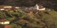
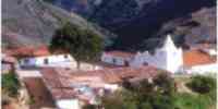
TRADITIONS
The calipso and the carnival are symbols of the culture
of The Callao, and of the state Bolivar. The Callao it
is a mining town where they mixed different cultures:
Venezuelan, Englishman,
North American, French and Antillean. Of there rich
traditions have arisen, as the calipso and the one carnival.
The calipso is a music that acquired in Venezuela
certain peculiarities: refrains
sung in patois or creole, picaresque letters and
narration of local events. The instruments
that they are used they are: wooden drums, four,
maracas, rallos and bells. It highlights, as
it guides musical of the celebration, the drum bumbac
that is loaded with a belt on the one
shoulder.
The carnival, based on the cheerful compasses of the
calipso, gathers processions of disguises and
dancers that carry out parades chanting songs. Among the
key characters they highlight: those
Madamas, women that shine handkerchiefs knotted in the
head and showy robes to the way
traditional of the matrons; the Devils, dresses of red
and black, exhibit masks
impressive and with their tridents they open step to the
processions, and the Mediopinto, individuals
that they stroll with their faces and blackened hands
and they load paintings to anoint people.


 Eco-Portal
Wildlife Venezuela
Eco-Portal
Wildlife Venezuela 