AMAZON State
Geopolitical division
In 1856 the County of Amazons is believed, well-known as Territory
of Black River, the one which it was part of the County of
Guayana. This is constituted as Federal Territory in 1864.
In 1940 it is conformed by the departments: Atabapo, Atures,
Casiquiare and Black River.
July 29 1992 are high to the state category. September 24 1994
you
it divides in 04 departments.
MAP VIAL
The growth of the state has contributed to improve the
communication roads in the area.
Although their main centers populated distan much of being big
cities, we would rot
to mention: Maroa, Ocamo, San Carlos of Black River, San Fernando
of Atabapo, Santa Rosa
of Amanadona, Tama-Tama and Yavita like expansion poles for the
XXI century.
Basic DATA
Capital
Port Ayacucho.
Location
Region of Guayana.
Limits
North: Bolivar.
South: Brazil.
This: Brazil and Bolivar.
West: Colombia.
Surface
177 617 km2.
Percentage of the national territory
19,38%. it is the second entity with bigger surface of the
country.
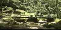
TOURISM
In Puerto Ayacucho it is the Museo Etnológico, with
their exhibition that shows the history of the indigenous ethnoses
of the area. If it is weekend, the boulevard it charges life with
the market
indigenous and their autochthonous pieces. Many take advantage to
escape until Casuarito, a Colombian village that you leave from
Puerto Ayacucho's jetty. In the outskirts it is the one Toboggan
of the Forest, a natural decline that finishes in a great grave of
icy waters. One
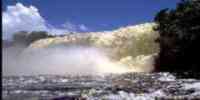
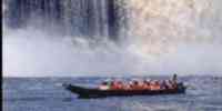
of the most popular sports it is the rafting for the streams of
Atures and Maipures. Another attractiveness is the Spa Blue
Well with its crystalline waters. Five exist majestic natural
monuments: Stone of the Cocuy, a rock that almost possesses in the
summit three peaks vertical. It is an unique geologic formation in
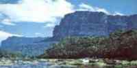
the world. Hill Autana, the sacred mountain of 1 300 m that is
crossed by a cave formed by cuarcitas in their superior part, only
in the planet. Tepuyes formation that shares with Bolivar. Stone
of the turtle, one great rock that likens a turtle petrified amid
the forest. And Colored Stone, one mass of black stone that has
recorded petroglifos. To 120 meters of the floor there is a cayman
and then a great snake whose head is guided toward the south.
Under the snake and to both
sides of the cayman, you can appreciate a man, a bird, an enormous
escalopendra and you figure that they liken petroglifos of Aztec
origin. It is worthwhile to travel until Samariapo and Port Venado
to take a boat to Island of Raton, Isla Morrocoy or Isla
Paloma.
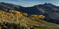
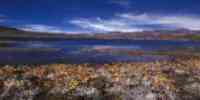
Geography
Geology
It is part of the guayano-Brazilian shield whose basement of age
precámbrica is
composed by metamorphic and granitic rocks. On this sustrato
is the Formation Roraima. Amazons belong to the County
fisiográfica of Guayana, originated by processes of
fracturación, rising, desnivelación and reduction taken place by
currents superficial and underground of waters. The floors come
from geologic formations of 1 300 to 1 400 million years, and they
have been subjected to meteorización processes and lixiviación
caused by the abundant rains and the high temperatures. This has
originated floors of low fertility.
Relief
Two flat areas exist: to the North, the valley of the rivers
Manapiare-Ventuari, and to the South, the penillanura of the river
Casiquiare. It has three big mountains: Maigualida, Parima and
Urucusiro-Tapirapeco-fog. The relief is formed for solid granitic,
plateaus and tepuyes that occupy extensive sectors, surpasses the
1 000 meters high and they begin in the end noroccidental, going
to the East and the South. They highlight formations with heights
superiors to 2 000 m.s.n.m., as the hills Guanay and Yaví.
Climate
The annual half temperature oscillates between 18º
and 26º Celsius. According to the classification Köeppen the one
climate is tropical with three varieties: rainy climate of
tropical forest (Af), tropical monzónico (Am) and of
savanna (Aw). The maxima precipitation values are presented toward
the Southwest, and they reach between 3 300 and 3 500
mm.
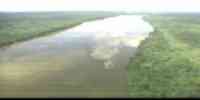
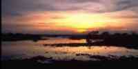
Hydrography
The net hidrográfica is organized in two main
basins: that of the Orinoco (it leaves high and mediates)
and it leaves of the basin of the Black Guainía-river. In this
region the river Orinoco 960 km travels. Among their tributaries
highlight: Ventuari, Padamo, Cunucunuma, Atabapo and Sipapo. The
basin of those rivers Guainía-river Black drena their waters to
the river Amazons in Brazil; has as main flowing to the
river Casiquiare. Here the hydraulic phenomenon of the Brazo
Casiquiare is given that it communicates the basins of the rivers
Orinoco and Amazons. The drainage net, when reflecting on more
resistant formations, gives origin to jumps and streams.
Other important rivers: Cataniapo, Manapiare, Mavaca, Ocamo,
Siapa, Orinoco in their high basin and mediates with their
streams Atures and Maipures.
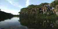
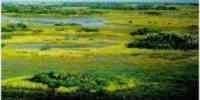
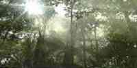
Vegetation
It presents the biggest diversity in vegetable
formations of the country, distributed in: Savanna of dry floors
with poor herbaceous vegetation in next sectors to Puerto
Ayacucho. Savannas of humid floors in the low basin of the river
Sipapo and the low lands of the Orinoco. The forests that cover
92% of the state, are formed by trees of more than 20 meters of
height. The main wooden species are: cedar, carapa, mijao, apamate
and saqui - saqui. When overcoming the 1 500 meters on the level
of the sea the vegetation it is represented for herbaceous species
and bushes of little development. In the entity some 5 000 are
known botanical species that represent the fourth part of the dear
flora of Venezuela.
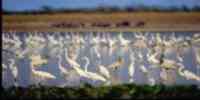
Fauna
The most representative fauna of mammals is
integrated by the monkey tití, the monkey claws, the amazon
squirrel, the báquiro white cheek, the otter and the giant
cachicamo. Among the birds you they count: the night paují, the
bird paragua, the guacamaya, and great variety of species of
toucans. The turtles are common in the net of rivers and pipes,
among them they highlight the terecay and the stubborn turtle of
the Amazons. Among the crocodiles it is common to observe the
black stifle. And of the ophidian ones, the snake lora and the
mapanare of the Amazons they are the most representative. In this
area exists varied species of frogs endemic arborícolas.
Mineral resources
To the south of the Orinoco is 80% of the
mining resources of the country. According to studies carried out
in the area, the grateful mineral resources are: manganese, iron,
gold, titanium, uranium, diamonds, molybdenum, bauxite, tin and
chromium.
Population
According to the XII General Census of Population
and Housing 1990, the state has a population of 55 717 hab. This
populational development places it in the twentieth fourth place
with regard to the one total national, with a density of 0,34
hab/km2, being one of the more entities uninhabited of the
country. The department of Atures concentrates the total
population's 88,32%, while the rest presents a great geographical
dispersion and it is located in small centers towns that follow
the course of the main rivers. Their population has experienced in
those last three decades a relative growth. For 1971 it was of
84,54%, for 1981 of 110,49%
and it stops 1990 it was of 22%. The Indigenous Census of 1992 the
autochthonous population estimated in 43 366 people, distributed
in 17 ethnic groups. The most numerous are: Yanomami, Guahíbo,
Piaroa and Yekuana. Each ethnos possesses a different language, as
well as a cultural tradition that it conditions the establishment
pattern, the space and the use of the resources natural.
NATIONAL PARKS
Four national parks exist: Serranía The Fog, located to the south
of the state, in those limits with Brazil; Yapacana, located to
the south of the state, to the Southwest of the fork of the river
Ventuari with the river Orinoco; Parima Tapirapecó, to the south,
in the nascent of the river Orinoco, in the Sierra of Parima in
the limits with Brazil; and Duida - Marahuaca, in the central
sector of the state.
Economic ACTIVITY
It is an economically depressed region. Its population's high
percentage depends on the one located constitutional. The
agricultural activity, practiced under the modality of “conucos”,
it is very limited by the drop quality of the floors. It produces
few surpluses to market, being their main items: caraota, corn,
sideburn, banana, yucca, cambur, mapuey and cane. The cattle
raising is extensive and inefficient, while the poultry keeping is
not able to compete with the production extraregional. Great part
of the potential of the fishing resources is underemployed, to to
weigh of existing in the area species like: Lined Bagre,
bocachico, poor target, curvinata, golden, palometa and bully. The
commercialization is restricted to Puerto Ayacucho, where one
single company takes charge of buying, to refrigerate and to sell
the products. The aserrío of wood and the extraction of secondary
forest products is rudimentary and it is subjected to strong
permisología restrictions. Among their main forest resources they
are counted: Rubber hevea, conger, I clot, guamo, yagrumo and
shoemaker. The wealth and abundance of landscapes natural it
favors the tourist potential.
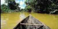
The indigenous presence is very strong in the area, of there that
they still stay traditions that they date of several hundred of
years. The means of transport is one of those symbols of the
ethnoses that they inhabit the state and that they refuse to die.
The curiara continues representing the road expedite to go from a
side to another. “The Indian boats don't call themselves in the
Orinoco canoes, but curiaras”. This the father wrote it
Felipe Salvador Gilij, missionary that the Amazonia traveled
Venezuelan during the second half of the XVIII century. The
curiara is made of a single stick; it is small, it oscillates
between the 3 and the 8 meters of longitude. The yekuana and
yanomami highlight as their big makers. The construction begins
with the selection of a tree of the one appropriate size. It
continues with the process of to extract or to carve the curiara
to hachazos. Then comes the emptying of the trunk, what
demands a meticulous treatment to give him forms oval to the
hole,
the ensanchamiento of their interior applying fire until achieving
that the opening acquires the one convenient diameter and later
on, the placement of the necessary crosspieces. Those curiaras,
once waste as crafts, they can be useful for the elaboration of
the one casabe.
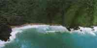
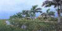
The Venezuelan territory is prolonged toward the south in an isthmus of green intense that it looks for the river-father's heads Orinoco -to little less than three degrees on the Ecuador-and extends on a dense forest played by the tributaries of the gigantic river Amazons. The first conquerors defined this territory like the Venezuelan Amazons, although the region takes a bath mainly for the nascent basin of the Orinoco, for that that, more appropiately, the Orinoquia should call herself. This vast state, the biggest second in the country, it is full of immaculate places, rarely frequented by the indigenous ones and never visited by the Creole. It harbors 15 of the 25 present tepuyes in Venezuela -all them natural monuments -, besides four of the most important national parks in the country: Duida-Marahuaca, Serranía The Fog, Yapacana and Parima-Tapirapecó. This catalog of natural marvels includes other four natural monuments: Stone of the Cocuy, Cerro Autana, Stone The Turtle and Colored Stone, besides the reservation of biosphere of the High Orinoco.
To the eyes of men and common women, the state Amazons seem a green and homogeneous unit, a calm intense sea of color emerald. However, the wild canopy that is alternated with the savannas hides the biggest possible diversity in Venezuela, so much of ethnoses as of atmospheres and wild life. Another region doesn't exist in the country that possesses such a profusion of birds, mammals, fish, reptiles and plants, different ecosystems and, mainly, of indigenous ethnoses.
Millennial cultures
Amazons are the state less town of the country: in their 175.750 square kilometers they live little more than 100 thousand people, a density of less than an inhabitant for square kilometer. Due to the scarce Creole population, indigenous territory is considered. They inhabit it 15 native ethnoses belonging to the families linguistic Arawak, caribe, obstruct-Guarani and other five independent families, where they figure the ethnoses yanomami, guajibo, warao, baré, ye'kuana and piaroa, among others. With 20 thousand members, the yanomami is the group that bigger population presents, in contrast with the piapoco that possess less than 100 members.
The lattice of forests and savannas arm with lands low inundables, plains, mountains, rocky blooming, tepuyes and -extensive and brief rivers. In these atmospheres they inhabit a total of 15 endemic species of mammals. Of this total, almost half of the species they are bats and six they are rodent or tune; they are also exclusive of the state kind of a monkey and one of weasel. Most of the birds of the state Amazons inhabit the other countries of the amazon basin equally. The beauty of species like toucans and cotingas are astonishing.
Obviously, the flora occupies a preeminencia place in the state. With hardly 5% of their territory explored with botanical ends, it already throws a dear of 25% of the species reported in Venezuela. It is easy to imagine that the one
I subtract of the territory to explore stores new species for the country or for the science; not in pail the quantity of traditional medicinal species is exorbitant and quickly it begins to nurture the world pharmaceutical industry.
To bird flight you can appreciate that good part of the state is covered for forests (a third of all the forests of the country is here); 10% that subtracts is distributed equally among other vegetable formations, as the savannas, arbustales and the pioneer vegetation that settles down on the rocky blooming, among others.
PLAINS
In the savannas of gramineous of the Amazons, as those that are distributed in the oriental riverside of the river Orinoco and in the high Ventuari, they inhabit typical species of the Venezuelan plains: mammals like deer caramerudos, bears anthills, chigüires, cachicamos and foxes and birds like the moriche and the real parrot.
Granitic LAJAS (AFLORAMIENTOS)
In the irregular surface of the quarter notes and rounded flagstones that run off with to the northwest of the state, pioneer plants that colonize the fissures grow and that, depending on the quantity of organic material accumulated in them, they end up forming from small colonies of grasses until true groves of even eight meters of high. The black coloration of the flagstones is due to the algae verdiazules incrusted in the surface of the rocks.
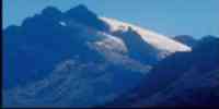
TEPUYES
In the summits of the tepuyes that in the case of the Mara -) huaca reaches the 2.800 meters high on the level of the sea, the relative isolation, the former climatic conditions and the poor floors in nutrients i has determined an important endemismo: species with dramatic adaptations that differentiate them vastly of those of those. low lands. Such it is the case of some plants that you/they take nutritious of the insects that catch.
PENILLANURAS AND LLANURAS INUNDABLES
In the low lands the fauna of the river invades the forest when it is flooded, the fish become forrajeros and the shallow waters travel in search of or" ' the fallen fruits of trees and palms. The coatí and many of the mammals that regularly traffic for the forest, they are forced to emigrate to higher lands or to become arborícelas.
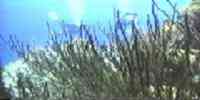
The rivers form extensive ecosystems that penetrate each 1 ^ corner of the state and they serve as main means of co-and municación. In them they don't lack astonishing inhabit-and aquatic teas, as the shakers and big bagres and tiny ornamental species as the escalares and the neons, traditional guests of the aquariums. Two species of river dolphins inhabit the stillest waters;
History
The territory of the state Amazons begins to take form from the foundation of the first missions, especially the established one for the father Jesuit Ignacio Fiol in 1680, in the place of the current Puerto Ayacucho. José Solano's early expeditions and Boat have the mission of establishing the limits between the possessions of Spain and Portugal. Solano orders to overcome the Orinoco until arriving to the streams of Atures in 1756, more than two and a half centuries after the discovery of America. For then it was believed that the Orinoco was born in the lagoon of the Parima or that of The Gilding and it is represented this way in the universal cartography: being born, with an incredible shrink, in that mythical lagoon. In 1842, José Antonio Páez establishes the district misional of Black River and in 1856 the county of Amazons, base of the current state is created. In that time their limits, although as soon as certain, they included part of the basin of the Orinoco that belongs to Colombia at the moment. In the year of 1864 stops to be county to become federal territory and later on, in 1992, becomes state Amazons, just as we know it today in day.
Amazons were a territory difficult to govern in their beginnings. The indigenous resistance to the conquest, in which the cacique stood out Aramare, was tenacious. It is counted that
years rn^s takes, between 1831 and 1908, there were 36 lifts organized by the local commanders. Parallelly, some scanners ventured for the Venezuelan Amazons. In 1800, the naturalistic Alexandervon Humboldty the botanical Aimeé Bonpland verified the connection of the basin of the Orinoco with that of the Amazons through the arm Casiquiare. Notables are the explorations of Codazzi in 1837, of Michelena and Red in 1855, of Chaffanjon in 1884 and one of the most fruitful: the franc-Venezuelan expedition of 1951 commanded by the biggest Franz Rísquez Iribarren that determines in a definitive way the heads of the river Orinoco. Disastrous characters also strolled for Amazons: at the beginning of the XX century appears the commander Tomás Funes, old soldier revolutionary that redamó for yes the rights of the smuggling of the rubber and the balatá and it instituted a terror reign to assure their interests. Funes paid with its own blood its audacity when it was shot in 1921 in San Fernando of Atabapo.
The old territory Amazons were an important supplier of one of the American products that forged the course of the universal history, during many years a strategic material for the industrialized nations. In their forests it grows wild the tree of the rubber -Hevea benthamiana - and the exploitation of its latex was translated in important revenues for Venezuela and Brazil until their seeds were germinated in England and sowed in Asia, giving origin to big cultivations that robbed South America of the monopoly of the rubber. The fever of the balatá generated small fortunes between the local merchants and a great affluence of adventurous, highwaymen and industry captains to the territories that were indigenous until the moment. It was unavoidable the cultural crash that led to the spill of blood and to the I face-lie for the lands between the Creole adventurers and the local Indians. Bloody disputes and the virtual esclavización of the natives marked this sad time of fortunes of the rubber. Today in day the synthetic rubber has excluded the industry of the natural one. However, the rubber tree was designated emblem of the state Amazons, as a reminder of the wealth that you/they are covered in the natural forests of our country.
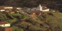
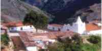
The capital of Amazons was alternated among Maroa, San Fernando of Atabapo and from 1928 until our days, Puerto Ayacucho, a city been founded strategically in 1924 waters under the streams of Atures.


 Eco-Portal
Wildlife Venezuela
Eco-Portal
Wildlife Venezuela 