NUEVA ESPARTA
State
Geopolitical division
Margarita County was erected in 1525. It is the oldest in the
counties that you/they formed
the General Captaincy of Venezuela. In 1821 it formed the
Department of the Orinoco. In 1863 it happened
to be a state of the Federation. In 1864 it is declared
independent and it forms the States
Together of Venezuela. In 1881 it integrates the state White Guzmán.
In 1898 she/he disintegrates,
being Aragua-Margarita sections transformed into a single entity.
In 1899 it arises
the state Margarita, which recaptures the name of New Esparta in
1901. In 1909 the one is believed
New state Esparta. Cubagua passed to be part of this starting from
1948. The entity you
it divides in eleven municipalities and eleven parishes.
MAP VIAL
The main terrestrial roads are the local one 5 that it crosses the
island from this to west; the local 4 and 1
that they cross the oriental sector of north to south; and the 11
that she/he goes from Tip of Stones to the
local 5. it Has a ferry service that communicates it with
mainland.
The most important populations are: Mouth of River, Juangriego,
Pampatar, Paraguachí and
Porlamar.
Basic DATA
Capital
The Asunción
Location
Insular region
Limits
North, South, This and West: Caribbean Sea
Surface
1 150 km2
Percentage of the national territory
0,13%. it is the veintitresava entity with bigger surface of the
country.
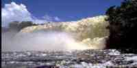
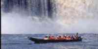
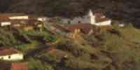
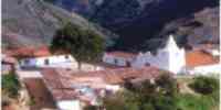
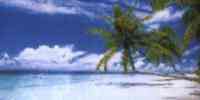
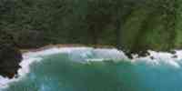
TOURISM
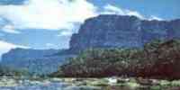
It has three natural monuments: Hill Braggart-Guayamurí, between
The Asunción and the
oriental coast.
Lagoon of The Marites, in the south of the island. And María
Guevara's Teats, in the oriental sector
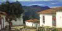
coastal. In The Asunción she/he is the Bridge of Stones or
Colonial Bridge, the Cathedral of
Our Mrs. of The Asunción -the first one that rose in the country
-, the Castle Santa Rosa and
Beach Guacuco. In Juangriego it is the Cave The Stones, the Ruins
of the Outpost of The Galley
and the beaches: Juangriego, Caribbean, Rasher, Fishing, Old Port,
Puerto Cruz, The Beach and Pedro
González. In Macanao and Mouth of the River is the Cluster San
Francisco, with walks to horse and
you dilute thermal. Pampatar, with The Headland, the Jester's
Caves, the Park of attractions Island
Magic and the Castle of San Carlos of Borromeo. In Porlamar she/he
is the church of San
Nicolás of Bari, the Museum of Contemporary Art Francisco Narváez
and the sanctuary of the
Virgin of the Valley. In The Tyrant it is Beach The Water, Tree
and The Tyrant. In Tip of Stones
the Museo Oceanográfico and Beach The Yaque. In Cubagua they are
the ruins of the city of New
Cádiz, first town of Venezuela and South America.
Geography
Geology
It is a continuation of the Mountainous System of the Caribbean,
separated from the continental coast for the
Depression of From Rio de Janeiro, characterized by vulcanismo
events, sedimentation, deposition and
rising. The litología is represented by the igneous-metamorphic
formations of the era
mesozoica, basement of María Guevara's mountainous groups of the
solid ones and of
Orinoco. The tertiary formations are the basement of the hills of
Pampatar, the biggest
it leaves of the coastal plane as well as some areas of the
peninsula of Macanao. The formations
quaternary of the pleistoceno and holoceno, they are evidenced in
the lowest marine terraces,
formed for alluvial, calcareous coast and alluvial, gritty
terraces and deposits
lagunares.
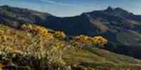
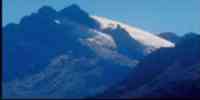
Relief
Margarita is conformed by two big blocks, united by a narrow
isthmus of little
elevation “Isthmus of The Restinga”. The western sector,
peninsula of Macanao, presents a
solid lengthened, from the hill Macanao until the hill Guarataro.
The oriental sector presents
in the mountainous solid part center-north three; she/he has as
features topographical resaltantes
the hills Copey (900 m), The Watch, Braggart and Guayamurí. The
solid oriental south has
a topography of low relief, except for the elevations located to
the north of Tip
Ram and in María Guevara's Teats.
The island of Car is in plane general, with some low hills.
Cubagua is the smallest
and their relief is plane.
Climate
According to the climatic classification of Köeppen their climate
is of steppe (Bs). it Presents two periods
rainy and two dry, oscillating the annual half pluviosidad between
300 and 900 mm. The distribution
of the rainy periods it allows to differentiate two areas: the
solid one mountainous oriental, where the
rainy station corresponds to the trimester
November-December-January.
The rest of the island, where the main rainy station corresponds a
period June-August. The
annual half temperature is characterized by the presence of two
maxima (May and September),
and two minima (January and December), with an annual half
temperature that it oscillates between 27 and 28 º
C.
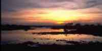
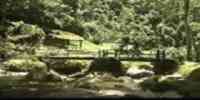
Hydrography
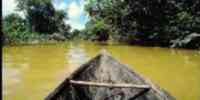
The rivers remain dry most of the year and torrential for short
periods. Those
few rains make that the resources hídricos is scarce. The main
rivers are: The Muco,
Chaguaramal, The Valley, The Asunción, The Old, Black, San
Francisco, San Juan and Tacarigua.
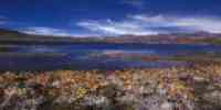
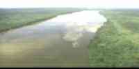
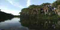
The lagoons: The Restinga, The Marites and The Martyrs.
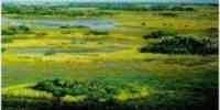
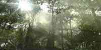
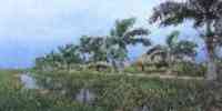
Vegetation
Except for some very reduced areas covered by a dense forest, the
vegetation
it lacks commercial value. In New Esparta the lands with high
agricultural potential are very
scarce. In forest resources they highlight: araguaney, cardón,
cují yaque, guayacán, jobo and
she/he will see.
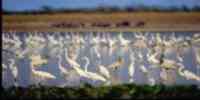
Fauna
Among the mammals they highlight: cunaguaro, mapurite, weasel,
deer caramerudo, rabbit
sabanero, cachicamo, squirrel and monkey. The partridge is the
most common bird. Among the reptiles: iguana
and morrocoy montañero. The ophidian ones: bell, mount mapanare
and tragavenado. Of those
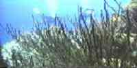
amphibians the toad is the most excellent. The state, for its
archipelago condition, counts with
a great variety of marine species, as: sardines, jurel, carite,
anchovy, flat, pargo, mere,
cazón, lobster, crab, oyster, guacuco, chipichipi, mussel,
octopus and squid.
Mineral resources
The islands that conform the entity don't have hydrocarbons
neither of hydroelectric potential.
The terrestrial mineral resources are limited to non metallic
minerals as: it burdens, sand,
limestone and stone.
Population
The state has a population of 263 748 hab, as it reports the XII
General Census of
Population and Housing 1990. This development places it in the
twentieth first place with concerning
to the national total; being their considered density of 244,15
hab/km2, one of the highest of the one
country. The populational growth experienced a constant ascent
from the decade of the 40.
The application of the ordinances of Frank Area and Free Port in
1971 they helped to the growth
populational. The immigration rate makes that that of growth of
New Esparta is one of
the highest. In populational importance the municipalities with
more number of inhabitants are:
Mariño (23,78%), García (12,65%) and Díaz (9,53%).
NATIONAL PARKS
It has two national parks: Hill Copey, in the part oriental center
of the island of
Margarita, with a surface of 7 130 has. And Lagoon of The
Restinga, in the north-central sector
that it unites the oriental part of the island with the peninsula
of Macanao. Their surface is of 18 862 there is.
Economic ACTIVITY
The economic base is based in the tourism, the trade and the
industry; activities
motive that have induced the growth of other, as the construction
and the transport. The
primary sector has little significance, its weakness it is a
logical reflection of the limitations that
it imposes the environment, the shortage of natural resources, in
the case of the works
agricultural, as well as the exploitation of minerals and the lack
of stimuli, in the case of the fishing.
In spite of this New Esparta is the third supplier of fish of
Venezuela. Also it is
the third entity producer of eggplant of the country. Cultivations
of corn also exist, melon,
paprika and tomato.
TRADITIONS
New Esparta is full with traditions. Among their typical
manifestations they highlight those
Oriental amusements, festivities that share with other towns of
the Venezuelan east and
that they are carried out between December and February. It
possesses theater elements, song and it dances. In the
previous stage to the celebration the arguments, parliaments,
letters and music of the are elaborated
procession that will be presented. Also they are carried out the
rehearsals and it is designed and it makes the
the participants' dress. A central character suffers the pursuit
amid situations
full with drama and arisen humor of the popular imagination.
Cestería structures, wire and wood, they are policromadas with
paintings or papers of
diverse quality and color to build the figure of a fish, rooster,
reptile, insect, boat or
any other possibility that allows to execute the representation.
In the signal date, the one
group comes out to travel the streets with a station in front of
the temple. The musicians aim the one
script with chords of four, guitar, bandolín, maracas and
tambora.


 Eco-Portal
Wildlife Venezuela
Eco-Portal
Wildlife Venezuela 