BARINAS
Geopolitical division
From their foundation in 1577, it belonged to
the County of the Sacred Spirit. Then
became in the County of Merida of the
Sacred Spirit of Screams Her. In
1622 became County of Merida
and Screams Her. In 1676 it passes of
being denominated County of Merida of the Sacred
Spirit of
Maracaibo. In 1823 it was divided in two
counties: Barinas and Hurry. In 1862 it changes
the name
of Barinas for that of Zamora. In 1881 form the
South state of West, being denominated in
1891 great Estado Zamora. In 1937 it recaptures
the name of Barinas. It is divided in eleven
municipalities and forty parishes.
MAP VIAL
Their main highway unites to the border states
with the rest of the country. By San Cristobal
and
Sacred Bárbara, and for Sacred Domingo via
Merida. Another route of relevance is the one
that drives toward the plain, exactly to
Puerto Nutrias in the river Hurries. The most
important populations they are: Arismendi,
Ciudad Bolivia, City of Otters, Freedom,
Bishops, Sabaneta and Socopó.
Basic DATA
Capital
Barinas.
Location
Region of the Plains and of you Walk them.
Limits
North: Trujillo, Portuguese and Cojedes.
South: Hurry.
This: Guárico.
West: Merida and Táchira.
Surface
35 200 km2.
Percentage of the national territory
3,84%. it is the eighth entity with bigger
surface of the country.
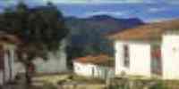
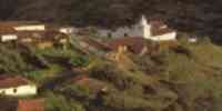
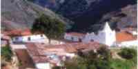
TOURISM
In the capital the points of interest are
centered in the Plaza Bolívar, the Marquis's
Palace where
the Government, the House of the Culture, works
where formerly it was the jail of
Barinas, the Cathedral, erected in honor to Our
Mrs. of the Pilar of Zaragoza, the church
Baroque San Nicolás of Aim of Bishops and the
Museum San Francisco of you Seize, with objects
that they remember the first times of the
region. As well as the Botanical Garden of the
UNELLEZ with a small one zoological and a
vivero to acquire ornamental, fruit-bearing and
forest plants.
Cataure is the Handmade Artistic Center located
in the outskirts of Barinas, via San Cristobal.
The waters thermal Pretty Pipe and the spas are
in Ciudad Bolivia: The Canal, Montañas
of Shell and Río Pagüey.
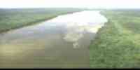
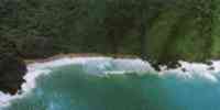
Geography
Geology
In the humid western high Plains extensive
alluvial plains prevail of the one
quaternary. In the Plains high Westerners
overflow plains exist and some of
deltaic type, formed by recent alluvial deposits
belonging to the quaternary one.
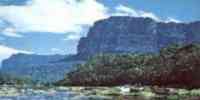
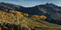
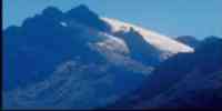
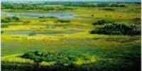
Relief
It presents a diversity of landscapes: moors,
mountains, piedemontes, valleys and plains
alluvial. They group in five regions: Walk them
Venezuelans: the landscape prevails of
mountain. The variation altitudinal is between
600 and 4 000 m.s.n.m. The western high Plains
humid: with extensive alluvial plains that
possess different systems deposicionales,
being plains of it overflows with deltaic
features and explayamiento plains
next to the plane piedemonte and of hills. The
Plains high western subhúmedos:
conformed by extensive overflow plains and some
of deltaic, formed type
for alluvial deposits, with a plane relief and
very low longitudinal slopes. One is given
alternation of bank positions, sandbank and
tideland. High it Hurries: with alluvial plains
of
overflow. Continental deltaic plains: the plains
prevail of it overflows, with
almost null slopes and subject to strong floods.
40% of the floors is usable for
agricultural activities.
Climate
In you Walk Them Venezuelans the climate it is
tropical humid and the annual half temperature
oscillates
between 5° and 26 °C. The annual half
precipitation varies between 900 and 3 200 mm.
In The humid western high Plains the climate is
tropical humid with half temperature
annual between 24° and 27 °C, the annual half
precipitation varies between 1 800 and 2 700 mm.
In The Plains high western subhúmedos the
climate is dry tropical with half temperature
annual among 26° and 27 °C, and a half
precipitation between 1200 and 1 800 mm. In the
High one Hurries the one climate is
tropical humid with annual half temperature of
26 °C and a half precipitation annual
between 2 200 and 2 500 mm.
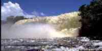
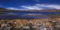
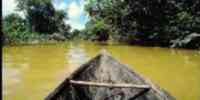
Hydrography
Numerous rivers that you/they are born in the
Mountain range converge of you Walk them: Sacred
Domingo, Boconó, Masparro, Curbatí,
Boilers, Pagüey, Capitanejo, Canal, Socopó,
Santa Bárbara, Caparo, Golden and
Uribante; that drenan their waters toward the
river Hurry. The abundance hídrica facilitates
the one use of this resource to generate
hydroelectricity.
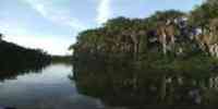
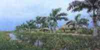
Vegetation
According to the classification of Holdridge,
the vegetation corresponds to: Tropical dry
forest (Bst) and Tropical humid forest
(Bht), having vegetable formations of: forest,
forest of
gallery, savanna, heath and moor. The most
frequent trees are: mahogany, cedar, charo,
sucking, I dredge, jobo, mijao, yokel, samán
and saqui-saqui.
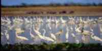
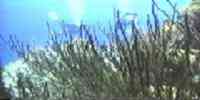
Fauna
They highlight: I dare anthill, cunaguaro, báquiro,
picure and chigüire. Among the birds: sparrow
hawk cousin, guacharaca, partridge montañera,
dove sabanera, duck whistler and a variety of
blue. The dribble is important in the aquatic hábitats.
The morrocoy sabanero is the turtle
more resaltante. Among the lizards it is
necessary to mention: I kill real, flat and
iguana, and of the amphibians, the frog
platanera.
Mineral resources
The mining potentiality is expressed by non
metallic minerals as: limestone, sand, silicato,
quartz, marble, red clay, feldespato, burdens,
sand silícea and fosforita. As for the resource
energy, reservations of hydrocarbons exist in
San Silvestre's south area, where you
they exploit several oil fields
Population
According to the XII General Census of
Population and Housing 1990, the population is
of 424 491
inhabitants, what locates to the entity in the
tenth seventh place with regard to the national
total.
The populational density is of 12,1 hab/km2.
most of the population concentrates in
the municipalities Barinas (41.54%), Ezequiel
Zamora (8.82%) and Pedraza (8.02%). The location
strategic of the state as transition area
between the Andean states and the region center
-
western, more the existence of diverse natural
resources, they have transformed it into a
important population receiver in the last 30
years, overcoming the national rate. Also
of this process inmigratorio, an internal
movement is presented toward the main centers
towns, accelerating the urban growth.
NATIONAL PARKS
It has two national parks: Sierra Nevada,
located in a surface of 276 446
hectares to the occident of the country, in the
center of you Walk them Venezuelans, among the
states Merida and Barinas. And
Cover-Caparo, in the limits of the states
Merida, Táchira and Trujillo.
It occupies a surface of 205 000 hectares.
Economic ACTIVITY
The most important is the agricultural one. It
is the first producing of cotton of the country;
the second in sunflower and banana, and the
third in corn, sorghum, caraota, ajonjolí,
ocumo, milky and sideburn. It is also
harvested: cambur, rice, yam, yucca and coffee.
In the cattle sector it is the third producing
of bovine livestock, and the third in milk. It
contributes a good quantity from cheeses to the
one national market.
The forest activity is significant; it is the
second entity of the country as for the
production
wooden in rola, with approximately 20% of the
national production. The activity
oil company in San Silvestre's wells also had
certain importance. Other industries
significant they are: leathers, weatherbeaten
skins and agroindustrial products of cereals.
TRADITIONS
The capacity to adapt at the new times has
allowed to the joropo to stay to inclination
of the years like the main musical manifestation
of Venezuela. In the decade of the 50 the one
joropo llanero achieved a great commercial
development. Figures that took this rhythm,
appeared
with great success, to the big cities, as
teacher Juan Vicente Torrealba.
Parallelly, the rural musicians you
profesionalizaron. This process brought I get
changes in the message of the joropo, expressed
in accusation letters and protests. Inside
those
new spaces opened up in the big cities
interpreters arose like: angel Custodio
Loyola, Redheaded Carpio, Reyna Lucero, Cristóbal
Jiménez, Reynaldo Armas and The Carrao of
Palmarito, among others. The central joropo is
one of those most diffused ones. It is
traditional in the one Barinas and it is
interpreted with harp, four, maracas and crop
(voice). however, in
many regions llaneras is substituted the harp by
the bandola. This happens particularly in
Barinas, of where is Anselmo López, the
“King of the bandola”; one of their bigger
ones
exponents.


 Eco-Portal
Wildlife Venezuela
Eco-Portal
Wildlife Venezuela 