YARACUY State
Geopolitical division
In 1527 it was part of the County of Venezuela. Then to the County
of Caracas and later
to the County of Carabobo. In 1824 it belonged to the County of
Carabobo. In 1856 you
became independent county. In 1864 it becomes state. From
1899 stays
as federal entity. It is divided in eight municipalities and seven
parishes.
MAP VIAL
The most important road is the troncal 1, with the tract San
Felipe-moron of the freeway center -
western and the troncal 11 that also communicates it with
Carabobo. has a rail line
that it goes by several populated centers, because it connects
Barquisimeto with Puerto Cabello. And another
that it communicates with Portuguese. The populations highlight
of: Aroa, Chivacoa, Cocorote, Marín,
Nirgua, Savanna of Vine, Yaritagua and Urachiche.
Basic DATA
Capital
San Felipe
Location
Center-western region
Limits
North: Falcon
South: Cojedes
This: Carabobo
West: Lara
Surface
7 100 km2
Percentage of the national territory
0,77%. it is the nineteenth entity with bigger surface of the
country.
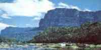
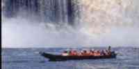
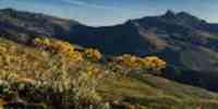
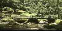
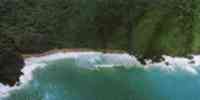
TOURISM
has as natural monument María Lionza's mountain, in the
Solid of Nirgua, in
Chivacoa; where is María Lionza's sanctuary. The Monument
is in San Felipe
to the Indian Yaracuy, the Parque Leonor Bernabó with their
pools, the Historical-archaeological Park
San Felipe The Strong one and the National Park Yurubí. In Aroa
it is the Parque Bolivariano Minas
of Aroa, with the ruins of the mines and remains of apparatuses
used for the excavations;
a spa of clear waters also exists. José Antonio Páez House is in
Guama,
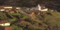
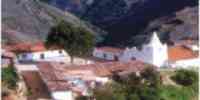
where the Centaur of the Plains lived in his childhood. In Nirgua
they are the Ruins of San
Vicente, a castle where stayed the extracted gold of the
mines, and the Cerro Picacho with their
petroglifos; very close the Embalse Cumaripa is.
Geography
Geology
It is conformed by three spaces: Solid of Nirgua, Sierra of Aroa
and Bobare, separated for
the depression Cloudy-Yaracuy and the valley of the river Aroa.
The masses orográficas and the structures
geomorfológicas is constituted by the formations Nirgua, Aroa and
the Complex Yaritagua,
formed by metamorphic rocks with diverse alteration degrees.
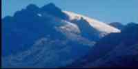
Relief
It corresponds to the sector where it finishes the Mountain range
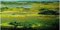
of you Walk them and the Mountain range of the begins Costa. It possesses plains of deltaic and marine constitution, a
tectonic depression (Cloudy -
Yaracuy), fence first floor, a piedemonte fringe and mountainous
formations with heights
superiors to the 1 000 m.s.n.m. To the northwest it is constituted
by solid materials that
they originate a deltaic formation of not very compact floors,
with an abundant aquifer mantel
that it forms marshes, swamps and lagoons. In the center the
Sierra of Aroa rises that divides
the two main depressions, presenting elevations like the picks The
Tiger, Paragüito and
The Round one. To the southeast the Solid of Nirgua, the most
uneven area in the is located
Mountain range of the Costa, when constituting the point of
encounter of the two mountainous chains of
this mountain range: the serranías of the Coast and of the
Interior. The flat sector finishes in the coast on
the Caribbean Sea. To the north floors are located with prevalence
of sand and slime, while others
sectors present franc-arcillo-oozy character.
Climate
According to the Climatic Classification of Köeppen the climate
is of savanna (Aw) and of steppe
(Bs) with an annual half temperature of 26,1 °C and annual half
precipitation of 1 900 mm.
It presents an annual half temperature that it oscillates between
20 and 26° Celsius.
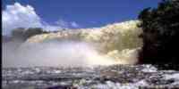
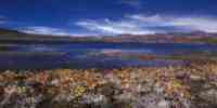
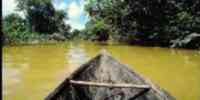
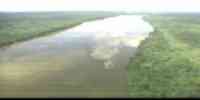
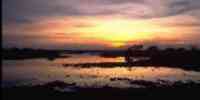
Hydrography
The waters escurrentes is divided in two slopes: that of the Sea
caribe, constituted by those
basins of the rivers Yaracuy and Aroa, and that of the Atlantic,
where drenan the rivers Cabuy, Cloudy,
Buría and Nirgua, which conform the system hidrográfico of the
rivers Cojedes and San Carlos.
It has a potential of underground waters that outlines very
positive perspectives for the one
I develop of the agriculture. Three areas of hydraulic use exist,
you dam them: Engineer
Francisco Amelinck, Engineer Germán R. Carballo and Engineer Hipólito
K. Rodríguez. Among the rivers
main they highlight: Aroa, Carabobo, Crucito, Chary, Guama,
Marcano, Nirgua, Tamboral,
Taría, Obstructs, Cloudy, Yaracuy, Yurubí and Yumare.
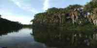
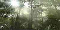
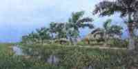
Vegetation
To the north the forest macrotérmica prevails in the Sierra of
Aroa and in the Solid of Nirgua you
observes the cloudy forest to an altitude of 800 m.s.n.m
and the gallery forest along the river
Yaracuy. 39% of the lands presents favorable conditions for the
agricultural development. The
forest potential is represented for: locust, bucare, cedar,
jabillo, mijao, oak and samán.
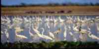
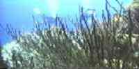
Fauna
The characteristic mammals are: danta, limpet, cunaguaro and
monkey capuchino. Among the birds
they are: mountain partridge, camata, golden quetzal and eagle
blanquinegro. Those are plentiful
poisonous snakes: mapanare and candle tail, and among those not
poisonous: queen and
tragavenado. They are common the marsupial frog and the
mountainous toad.
Mineral resources
They are represented for: sand, burdens, red clay, limestone,
talc, marble and it upsets. Of those
metallic minerals exist antimony, residual iron, lead and
ilmenita. Other resources
existent in the entity they are: get paid, dolomita, gold, pyre,
silver, titanium and plaster.
Population
It occupies the décimooctavo place with regard to the national
total, with 384 536 hab according to the XII one
I take a census of General of Population and Housing 1990. Their
density is of 58,2 hab/km2. The growth
populational it is bound to the quick urbanization process in the
last decades, since
it passes of 38% of urban population in 1950 to 76% in 1990. As
for the distribution
populational, San Felipe, the capital, concentrates 17,70% and the
rest is distributed among
Yaritagua, Chivacoa, Nirgua, Cocorote and Albarico.
NATIONAL PARKS
Two National Parks exist: Tirgua (General Manuel Manrique),
located among the state
Carabobo and the municipality Nirgua of the state Yaracuy. Yurubí,
to San Felipe's north, in the one
sector Hill The Tiger-Chimborazo.
Economic ACTIVITY
The main activity is the agriculture. Of there that it is the
first producing of orange of the country;
the second in batata; and the third in avocado, peanut, paprika,
cane of sugar and palm
oil bottle. also takes place, although in smaller measure:
corn, cambur, caraota, coffee, sorghum,
banana, eggplant, bean and tomato. In the rivers it is given the
cachama fishing and bagre. As for the one
cattle sector, goats and bulls are raised. The industrial activity
is incipient, however there is
companies dedicated to the refined elaboration of sugar and paper
pulp.
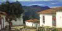
TRADITIONS
The word wake is good to denominate to the act of veiling a
deceased, to name those
celebrations devocionales around a saint or to define the party of
The Cruz, the one which you
carries out May 3. The Wakes of Cruz come from agrarian
rites and with them it is looked for, year
to year, to propitiate the crop. Musically they are formed by
songs of: save, tone and tenth,
and in almost the whole Portuguese state, also for romance and
refrain. Survive it sings at two
voices. The tone is interpreted, also to two voices, but for three
couples of singers that you
they alternate. There are tones of passion (religious content) and
of toy (you fear pagans). Those
festivities are carried out as much in the streets as in the
houses, the important thing is that you
install a prepared altar for the occasion in which the cross
occupies the seat of honor.


 Eco-Portal
Wildlife Venezuela
Eco-Portal
Wildlife Venezuela 