GUÁRICO
Geopolitical division
With the creation of the first counties, Guárico was part of the
County of Venezuela.
Later on member of the County of Caracas became. In 1848, she/he
is formed the County
of Guárico. In 1864 it passes to belong to the state White Guzmán,
recovering their personality
as state in 1899. It is divided in fourteen municipalities and
thirty nine parishes.
MAP VIAL
The two main communication roads are: the highway that leads to
the plains of the south and the
that it crosses the state from this to west. Among the most
important populations they are counted:
Prison, Camaguán, Chaguaramas, The Mercedes, Santa María of
Ipire, Tucupido, Valley of
The Easter and Chintz.
Basic DATA
Capital
San Juan of The Muzzles.
Location
Region of The Plains.
Limits
North: Miranda, Aragua and Carabobo.
South: Bolivar and Hurry.
This: Anzoátegui.
West: Cojedes and Barinas.
Surface
64 986 km2.
Percentage of the national territory
7,09%. it is the fourth entity with bigger surface of the country.
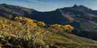
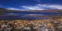
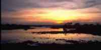
TOURISM
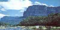
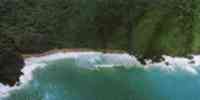
It has two natural monuments: San Juan's Muzzles, in the
denominated place The
Door of the Plains. It is formed by jagged hills that seem some at
the distance
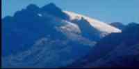
castles in ruins. And the hill Platillón that is the highest in
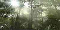
the Serranía of the Interior. The landscape
it is mountainous, with a mass boscosa always cloudy. There
important tributaries are born of the one
river Guárico that feeds the reservoir of the region. It was also
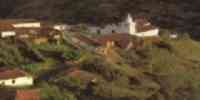
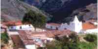
called Juan Germán Roscio.
In the square Bolivar of the capital the San Juanote, San Juan's
40 statue is
meters of high. The thermal bathrooms of San Juan of the Muzzles
are in the same area, with
you dilute sulfurous of superior temperatures to the 30 °C. The
spa The Muzzles and The
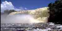
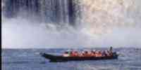
Castrero. In the road the Tidelands of Camaguán are to San
Fernando. In Cabruta she/he is
the national park Aguaro-Guariquito to enjoy the savanna
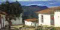
ecosystem. In Prison
it highlights the Park it Dams It, the Cathedral (built among
1754-1790) and the church of Those
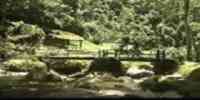
Mercedes. In Valley of The Easter, the reservoirs: The Easter and
Tamanaco. As well as those
towns of Thorn, Santa María of Ipire and Tucupido.
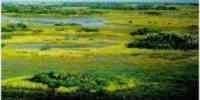
Geography
Relief
It belongs to the natural counties of the central Plains and the
System of the Costa. Those
Central plains have landscapes of denudación plateaus and of
tables, valleys, plains
alluvial and eolic. The denudación plateau possesses a wavy
relief with slopes of
3 to 8% and hills with slopes of 8%. The relief of the table
plateau varies of plane to
wavy, with slopes between 1 and 3% and borders of banks
disectados. The valley landscape is
of vegas and terraces of plane relief to lightly wavy, with slopes
smaller than 3%.
The alluvial plains have extensive areas of plane relief with
slopes from 0 to 3%.
The eolic plains are of plane relief to wavy and slopes of 1 to
8%. The System of the
Costa has a mountain landscape and the piedemonte sector presents
an uneven relief
with slopes between 25% and 40%, respectively. The floors are
loamy with variations
of texture. In the plane areas the drainage is faulty. Areas of
lands exist of high and
moderated fertility in the valleys along the numerous rivers.
Climate
The temperatures annual stockings are superior to 26 ºC.
According to the classification
climatic of Köeppen, the predominant climate is of savanna (Aw).
The precipitation average
it oscillates among annual 1 000-1 500 mm. A marked distribution
of the rains is observed in
two periods, one between the months of November and April, and the
rainy one of May to October.
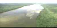
The system hidrográfico is conformed by the rivers: Orinoco,
Portuguese, Smutty, Guárico,
Orituco, Guariquito, Manapire, Tamanaco and Zuata that drenan
toward two big slopes: the
of the Caribbean, understood by the rivers of the basin of the
Unare, and that of the Atlantic, constituted for
the courses of water that Orinoco flows toward the basin of the
river.
It has two important aquifer: one to the east, toward the sector
of Tucupido, and the other one to the south
of Prison. Several systems exist of you dam for the watering,
among those that highlight: the
it dams of the Guárico and the reservoirs Beach of Stone and
Guanapito.
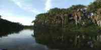
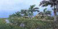
Vegetation
The vegetable covering is represented in the tropical dry forest,
which one of those constitutes
set natural more extensive of the country, with arboreal strata,
formations arbustivas,
herbaceous and typical savannas of the floor tropical altitudinal.
The readiness of agricultural lands is
of approximately 50% of moderate potential to high, capable for
the agricultural exploitation
vegetable y/o the intensive cattle raising and semiintensiva. The
forest resources are limited for
the physical-natural conditions. They highlight: olive tree,
araguaney, ceiba, cherry tree, I dredge, jobo, puy
and saqui-saqui.
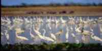
Fauna
Among the mammals they highlight: chigüire, deer, báquiro,
cunaguaro, fox, mountain cat and
diverse species of monkeys. The most abundant reptiles are: you
dribble, tortoises and snakes of
it dilutes. The most outstanding aquatic birds are: cotúa zamura,
cotúa needle, bird of black,
blue, íbises and yokels.
Mineral resources
It has a great reservation of natural gas. To the south of the
state the oil strip is located of the one
Orinoco, where the perforation of exploratory wells of the
subcuenca has been reactivated
Guárico. They also exist: sands silíceas, barita, burdens,
plaster and zinc.
Population
The population is of 488 623 hab according to the XII General
Census of Population and Housing 1990,
being placed in the fifteenth place with regard to the national
total. The populational density
it is of 7,5 hab/km2, 12,4 hab/km2 less than the national average.
The rates of growth
presently century, they show growths and not very significant
decrecimientos. The population
it is distributed fundamentally in three municipalities: Miranda
(18,93%), Infant (16,26%) and
Roscio (15,25%), in which concentrate the three more important
cities of the entity:
Prison, Valley of the Easter and San Juan of the Muzzles,
respectively, constituting those
main centers of industrial localization and development of
economic activities.
NATIONAL PARKS
It possesses two national parks: Aguaro Guariquito, in the Central
Plains, to the south of the state.
And Guatopo, in the mountainous region of the Serranía of the
interior, among Santa Teresa of the Tuy
(state Miranda) to the north and Altagracia of Orituco (Guárico)
to the south.
Economic ACTIVITY
The main economic activity is the agricultural one. It occupies
the first place in the production of
sorghum, caraota, mango, bean, melon, sideburn and tomato; it is
the second in rice, corn, milky and
onion; and the third in cotton, soya and tobacco. It has been able
to generate linkages with the one
agroindustrial sector, supported by the existence of 16 reservoirs
and three watering systems. The
cattle raising of bovine and of swinish it places to the state as
one of the main ones
suppliers of agricultural products. As for the timber activity, it
is located in the one
seventh place with regard to the national total. The industries of
petroleum, natural gas and I cement
they are the most representative.
TRADITIONS
The joropo llanero is interpreted during the whole year in the
central plains of the states
Guárico, Hurry, Cojedes, Barinas and Portuguese. However, in the
departments of the Goal,
Vichada, Casanare and Arauca of Colombia are also cultivated with
characteristic very similar.
With spending of the years the joropo llanero it was subdivided in
two big musical forms:
blows and passages. To the first one she/he is qualified as hefty,
while the second she/he has a
more lyrical character. In the blows she/he is sung to the heroic
thing, the tradition, the love to the earth, the one
I root, the defense of the identity, the patriotic thing and the
colombo-Venezuelan fraternity. For its
it leaves, the passage is more romantic and she/he sings to the
love and the earth fundamentally. In those
Plains stand out a diversity in ways of joropos of great musical
wealth. It fits
to mention: Pajarillo (the most diffused one), Catira (their
letters sing the woman), it Hums that it hums
(it requires of a technique purified for their execution),
Sanrafael (the topics usually rotate in
lathe to the fishing), Six for right (it is the most
representative blow), Six perreao (it is one
variant of the six for right) and Quirpa (a blow of 3x4).


 Eco-Portal
Wildlife Venezuela
Eco-Portal
Wildlife Venezuela 