ARAGUA
Geopolitical division
February 8 1848 are believed the County of Aragua. In
1863 figure as state Aragua,
up to 1873 when takes the name of White Guzmán.
In the Constitution of 1881 it conforms the one
Great State White Guzmán. In 1889 it is recognized
again as state Aragua. In
1917 are named to Maracay like their capital. The entity
is divided in fifteen municipalities and
twenty-five parishes.
MAP VIAL
The main one via it is the regional freeway of the
center. From Turmero the highway begins that
it drives to the Plains. From Maracay it leaves a road
toward it Tastes and Ocumare of the Costa, and
another that leads to Choroní. Some important cities
are: Cagua, Camatagua, The
Council, The Victoria, Ocumare of the Costa, San
Casimiro, San Mateo, San Sebastián, Turmero
and Villa of Cure.
Basic DATA
Capital
Maracay.
Location
Central region.
Limits
North: Caribbean Sea.
South: Guárico.
This: Miranda, Guárico and Vargas.
West: Carabobo and Guárico.
Surface
7 014 km2.
Percentage of the national territory
0,76%. twentieth entity with bigger surface of the
country.
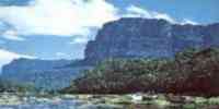
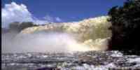
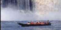
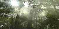
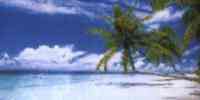
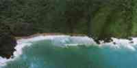
TOURISM
concentrates on the area of the Costa, where they
contrast the forest of the national park Henry
Pittier and the paradisiac beaches of Choroní and
Puerto Colombia (with their rivers, wells, gulches,
natural toboggans and their lively pier), Ocumare of The
Costa, Cuyagua, Tastes and Catica.
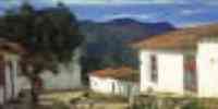
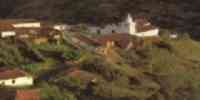
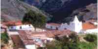
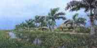
In this state it is the Colonia Tovar, a town that
maintains the architecture characteristic of those
German that built it. It can be arrived by The Rush or
for a highway that leaves
of The Victoria. In this last route there is an area of
well-known parapentistas as Placivel.
Leaving The Colony a road leads to Puerto Cruz's beaches
and Mayan Port; from
this last one takes peñeros that take to Tunja, Cepe
and Chuao (famous for their cocoa). In The
Council is the Treasury Santa Teresa, with walks to know
the production of rum. In the
capital is interesting museums, as the aeronautical one,
that of anthropology and history, the one of
archaeology, and that of fine arts. is also the
Chapel of the Augustinian Sisters
Recoletas, where the remains of San José's Madre María
lie, ascended devout person in 1995.
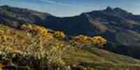
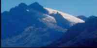
It has a natural monument, the Pico Codazzi, in the
limit with Miranda.
Geography
Geology
The litología of its mountainous areas is conformed by
rocks of diverse degrees of
metamorfismo, and for some igneous and sedimentary.
Their anticlinales structure and sinclinales
it evidences the geologic dynamics of the area. In the
Central Plains and in the Depression of the lake of
Valencia, the sedimentary material prevails, which has
been deposited in times
recent. Five natural regions differ: Serranía of the
Coast, Depression of the lake of
Valencia, Serranía of the Interior, Piedemonte of Hills
and Galleys of the Serranía of the Interior and Wavy
plains. Aragua possesses near 311 967 hectares of lands
with diverse degrees
of agricultural potentiality that you/they represent
44,5 capable% for diverse uses.
Relief
It corresponds to the Mountain range of the Costa.
Between the valleys of Aragua and the oriental part are of
the lake of Valencia. The slope and the topography
varies from abrupt and broken reliefs
with superior slopes to 40%, until reliefs of wavy
topography to page, with
smaller slopes to 5%. In the north end mountainous areas
are presented whose heights
they vary between 600 and 2 400 m.s.n.m. The Serranía
of the Interior occupies the central part and its
heights they go from 500 to 1 900 m.s.n.m. The
south part corresponds to extensions of plains, with heights
between 150 and 300 m.s.n.m. The biggest elevations are
the picks Ash and Agustín
Codazzi in the Mountain range of the Costa, and the pick
Platillón in the Serranía of the Interior.
Climate
Varied floors bioclimáticos exists, from the tropical
one very dry in the north, until the montano
under humid in the mountainous areas, while in the
Depression of the Lake of Valencia and
in the south a dry tropical climate is given. The annual
half temperature varies between 25º and 27 ºC, with a
precipitation average of 1 000 mm.
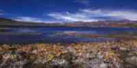
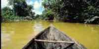
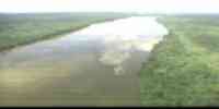
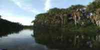
Hydrography
Their net hidrográfica is part of three big basins:
that of the Caribbean Sea that includes the rivers
San Miguel, Ocumare, Tastes, Guarapito, Aroa and,
through the river Tuy, the rivers of his
high basin; the basin of the river Orinoco, formed by
the high basin and it leaves of the half basin
of the river Guárico and the half basin of the river
Memo; and lastly, the basin endorréica of the lake of Valencia
where they pour their waters the rivers Aragua, Turmero,
Maracay, Cover-cover, Tocorón and The Mines. This
rivers are transformed at the moment into the main
collectors of
discharges of served waters, so much of the
urban-industrial use as agricultural. Other tributaries
important they are: Aragua, Guárico, Lemon, Pao,
Turmero, Tuy in their high basin and Zuata.
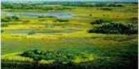
Vegetation
It is subject to an intervention process, especially in
the vicinity of the areas
agricultural and urban. The forests are located in the
Serranía of the Interior and of the Coast. Those
heaths occupy part of the valleys of the Tuy, the next
sectors to the reservoir of Camatagua
and the mountainous hillsides. The herbazales prevails
toward the hills and skirts of the discharges
mountains located between The Council and the Colonia
Tovar, and in the sector understood among
Cagua, Villa of Cure and you would Knit. The savannas
are to the south, and the espinares they are located in
those
coastal sectors to the north. In these vegetable
formations species exist like: acapro,
mijao, samán, jobo, I dredge, apamate, mahogany, cedar,
ceiba, caracaro, camoruco, carabalí and
carapo.
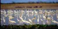
Fauna
Among the mammals they are counted: dog of water, rat of
water, girthed báquiro, araguato,
limpet, picure and tigrillo or margay. The paují stone
crest, the penned sorocuá, the eagle
solitary and the pick of flask emerald is the
characteristic birds. The mapanare, the tigra
butterfly and the bell are the poisonous snakes of the
area, as well as the tragavenado, the
queen and the verdegallo whose sting is not mortal.
Among the amphibians they highlight the lined toad, the
marsupial frog and a series of species of frogs arborícolas.
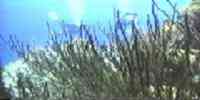
The main marine species are: shrimp, lobster, squid,
mere, carite,
pargo, jurel, cataco, sardine and tuna. In the lake of
Valencia the most common are: bocón,
guabina and bagre.
Mineral resources
The energy resources are limited to the possible
existence of coal in a narrow strip of the one
piedemonte, to the south of the Serranía of the
Interior. In the north there are metallic minerals as
copper,
cobalt, chromium, nickel, lead, zinc, barita and basalt,
and abundant non metallic minerals. The
south only possesses not mineral resources metallic as
marble, limestone, sand and clay.
Population
According to their population it occupies the sixth
place with regard to the national total. According to
the XII one I take a census of General of
Population and Housing 1990, has 1 120 132 hab.
Population's density it is of 127,7 hab/km2. The
economic impulse that the industrial activity has
provided to to leave of the decade of the fifties,
it is manifested in a geographical dynamism that locates
the one state as one of the main areas population
receptoras, observing you rates of
growth discharges, very above the national value. This
way: 1950 (3,8%), 1961 (4,2%), 1971
(5,1%), 1981 (6,1%) and 1990 (6,2%). This population has
been distributed in an irregular way on
the space estadal. 15,65% concentrates on the
municipality Santiago Mariño, followed by the one
municipality José Félix Ribas with 11,77%.
NATIONAL PARKS
It only possesses a national park, the Henri Pittier,
that occupies 107 800 hectares in the tract of
the Mountain range of The Costa that extends to the
states Aragua and Carabobo.
Economic ACTIVITY
The industrialization process, particularly in the
Depression of the lake of Valencia,
apparent the development of an important
urban-industrial formation. The industries of bigger
relevance is: self-driven vehicles, chemical products,
paper, textile, I cement, drinks
alcoholic and gassy. As for the cattle sector, it is the
first producing of swinish livestock
of the country and the second in birds; occupying the
seat of honor in the production of eggs. The
agriculture has registered an important growth. It is
the first producing of eggplant, the one
second of cucumber, and the third of tomato. Other items
of relevance are: corn, avocado,
milky, sorghum, onion, orange, potato, cambur, cane of
sugar, caraota, cocoa, cotton, coffee,
paprika and quinchoncho.
TRADITIONS
Cries her it is a Spanish name designated by the
conquerors to the indigenous ceremony of
watch of a body. The original characteristics got lost
and the deceased was substituted for
a puppet. At the present time Cries her it defines
to a dance traditional aragüeño, specifically of
The Victoria, with marked influence aborigine, European
and African. It includes choreography, music and a
very particular decoration. In the atmosphere the
vegetation plays an important paper.
Some bamboo sticks are placed in equis form and some
cambur undergrowths serve for
to define the space of the dancers and it separates them
of the musicians and of the spectators. Cries her it
is made up of six parts: the sambainina, the cow, the
bear, the spark, San Juan-the
Magdalena and the stick. The instrumentation is
conformed by the four, the drum, the maraca
Creole, the contrabass and the carángano aragüeño,
fact with wood and wire strings
resemblance to a long table; a performer uses two
sticks, also wooden, calls
laurels to hit the strings, while the other one uses one
it covered with small stones or
grains of corn in their interior to rub them.


 Eco-Portal
Wildlife Venezuela
Eco-Portal
Wildlife Venezuela 