MIRANDA
Geopolitical division
It belonged to the County of Venezuela.
Starting from 1830 it begins to be part
of others
entities during successive
political-territorial divisions. In 1864
it arises as entity
autonomous. In 1891 it integrates the
state White Guzmán. In 1899 it is
included inside the
County of Caracas. In 1904 it becomes an
autonomous entity. It is divided in
veintiún
municipalities and fifty three parishes.
MAP VIAL
It possesses a wide infrastructure
vial and a great percentage of freeways.
It has the system
of transport underground Meter of
Caracas from the station Chacaíto to
the station
terminal Green Stick. Among the
important populations they are counted:
Baruta, Caucagua, Cúa,
Charallave, Guarenas, Guatire,
Higuerote, Ocumare of the Tuy, Petare,
Small River, Santa Teresa,
Sacred Lucía and San Francisco of Yare.
Basic DATA
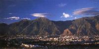
Capital
The Teques
Location
Capital region
Limits
North: Federal district and Caribbean
Sea
South: Guárico, Aragua and Anzoátegui
This: Caribbean Sea
West: Aragua
Surface
7 950 km2
Percentage of the national territory
0,87%. it is the tenth seventh entity
with bigger surface of the country.
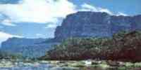
TOURISM
It has two natural monuments: the Cueva
Alfredo Jahn, the second more long of
the country,
located in Windward, near Curiepe. And
the Pico Codazzi, one of the highest
summits in the
Mountain range of the Costa, located in
the limits of the states Aragua and
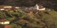
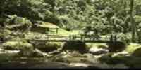
Miranda. In The Teques
she/he is the Park The Charm, to which
you consents taking a railroad in the
station Those
Lakes. For the same area it is the
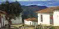
picturesque town of The Jarillo. The
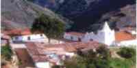
Sanctuary is in Cúa of
the Virgin of Betania. In Santa Lucía's
Church, in the population of the same
name, you
she/he finds Santa Lucía's altarpiece,
national monument made by Domingo Gutiérrez,
this way
as Santa Lucía's three statues. For the
properties of Higuerote it can leave to
the island of
Crop with their crystalline waters.
Other beaches of the cost mirandinas
frequented by those
inhabitant of Caracas are: Higuerote,
Small River, Chirimena, Chuspa and
French Port. Other points of interest
of the state is the town of The Hatillo,
the Parque Rómulo Betancourt, the Park
Those
Jets and the modern commercial centers:
Sambil, Center Commercial City Tamanaco
(C.C.C.T.), Concresa, Square The
America, Good fortune, The Cascade and
The Large house.
Geography
Geology
She/he acquired their physiognomy in the
third quaternary superior. The headlands
of the north coast
they come from a rising of the coast
that was given in the plioceno. It is
located inside two
lines orográficas: the Serranía of the
Coast and that of the Interior, with a
great depression among them, the
plain barloventeña, as well as the
valleys of the Tuy and the oriental part
of the valley of Caracas.
Relief
Serranía of the Coast: it presents
anticlinales, sinclinales, flaws and
diaclasas. A relief prevails
accident victim and abrupt, with pending
discharges, irregular, sharp crests and
of deep
explode, besides straits you fence
intramontanos. Serranía of the
Interior: lower than the one of the one Coast.
To the south it presents numerous
landslide flaws that serve as contact
among those
different geologic formations, besides
numerous fractures and diaclasas in the
rocks. The
relief has strong slopes that arrive up
to 70%. Oriental Sector of the Valley of
Caracas: it is a depression of the
Serranía of the Coast. The river Guaire
divides it in two fringes that they
differ for their decline. Fence of the
Tuy: they form a depression among the
two formations orográficas,
starting from which the plain barloventeña
that separates the serranías begins of
the Coast and of the Interior.
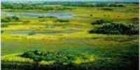
Depression of Windward: plain of
sedimentary origin where you they
identify low landscapes and planes:
fence, explayamiento plains and marine
coast subject to
a constant deposition of silts. The
potential of agricultural lands is
located in the
depression Guarenas-Guatire, Half Tuy,
valleys, plains and sectors colinosos of
Windward.
The plain of Windward is the one that
presents bigger surface of fertile
lands. The lands of the one
Tuy Medio shows medium potential, but
they have been underemployed with cattle
activities
and extensive cañícolas.
Climate
They exist several floors bioclimáticos
that vary from the tropical one, until
the low montano. The
pluviosidad averages yearly it is of 1
300 and 1 500 mm, product of the humid
Trade winds
that they enter for Windward. The rains
are present up to nine months. The
temperature
maxim and minimum it is of 27 ºC and 18
ºC, in the mountain range. In the
depressions the average is of 26 ºC.
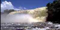
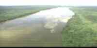
Hydrography
The net hidrográfica presents short
courses whose flow increases gradually
from the areas
drier until the most humid. The waters
drenan toward the Caribbean Sea. The
main basin
it is that of the river Tuy, and the
most important subcuencas they are:
Guaire, Cuira, Big, Guare,
Ocumarito, Lagartijo, Taguaza, Taguacita
and Broken Charallave. The readiness of
resources
hídricos is scarce to be inside the
biggest urban-industrial conglomerate in
the country. It counts
with the reservoirs: The Butterfly,
Lagartijo, The Laziness, Ocumarito,
Dilutes Cold, Taguaza, The
Handsome and Dry Gulch. The biggest
potential of underground waters offers
it the aquifer of
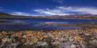
Windward. It possesses three lagoons:
Tacarigua, Crop and The Queen.
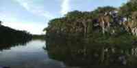
Vegetation
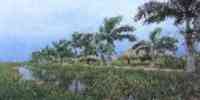
The vegetable formations are: forests,
heaths, espinares, herbazales, palmares
and
swamps. The dense vegetation of the
pluvial or rainy forest contrasts with
the xerófila that
it prevails in the slope that gives to
the Caribbean. The mangrove and the
palmar are characteristic of the coast.
In the mountainous areas and in the
interior valleys the forest tropófila
prevails. Those
forests are located on uneven
landscapes. The forest resources are
represented for: apamate, escobo, guamo,
hicaco, jabillo, jobo and tobacco.
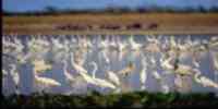
Fauna
The mammals are: deer reddish matacán
or locho, limpet, picure and monkey
araguato. Among those
birds: ponchas and red guacamaya. They
highlight among the reptiles: the bell,
the mapanare, the
leather jacket and the tragavenado. The
frog platanera and the common toad are
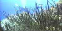
abundant. In the coast lagoons
exist where it is possible the
development of the fishing activity,
represented by species like: cunaro,
pargo, carite, jurel, lebranche, bass,
several types of
crab and shrimps. One has the haulage
fishing that is selective and it is
located in the fishing
camaronera of Windward; lacustrine that
is carried out in the lagoon of
Tacarigua and the handmade one carried
out along the coast.
Mineral resources
As for the mining potential,
basically they are located limestone,
sand, burdens and clay. They are had found
iron deposits in Capaya.
Population
According to the XII General Census of
Population and Housing 1990, Miranda
concentrates a total
populational of 1 871 093 hab, being
located in the second place among the
federal entities;
with a rate I average yearly of 3,1%
above the national average and a density
of
235,4 hab/km2, almost twelve times the
national average. Miranda is one of the
more spaces
towns, just by 0,9% of the national
territory, she/he has near the urban
population's 10%.
This behavior is justified because great
part of its territory belongs to the
area
metropolitan of Caracas through the
municipalities: Chacao, The Hatillo,
Baruta, Sucre and the
parish Cecilio Acosta, and because due
to the expansion necessity that has had
Caracas
it has been given the growth urbanístico
like cities bedrooms of The Teques, San
Antonio
of the High ones, Carrizal, Guarenas,
Guatire, and several populated centers
of the Half Tuy. Those
migratory processes, so much internal as
of the exterior, they have been intense
and the capital region has the main
receptora.
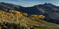
NATIONAL PARKS
It possesses five national parks: The Ávila
that shares with Vargas and the Federal
District;
it occupies the central tract of the
Mountain range of the Costa. Macarao
that shares with the District Federal.
Guatopo, in the mountainous region of
the Serranía of the Interior, occupies
the states Miranda and Guárico.
Lagoon of Tacarigua, in the region of
Windward.
Economic ACTIVITY
The industrial one is among the
important economic activities, mainly
the manufacturer,
that it constitutes, together with that
of the Federal District (through the
metropolitan area of Caracas and their
expansion areas: Pan-American highway,
Guarenas-Guatire and Half Tuy) the first
group urban manufacturer of the country.
They highlight in the industrial
environment: products
metalmecánicos, chemical and
nutritious, alcoholic and gassy drinks,
graphic arts,
fabrics and footwears, among others. The
financial, commercial activities and of
services they have
great importance. The development of the
sector tourism has come in ascent with
the construction of
facilities and hotel infrastructures.
The agricultural activities continue
having its
traditional importance, being the first
producing of milky, yam, ocumo and
cocoa; the one
second in caraota, and the third in
coconut and orange. It is also
cultivated: yucca, corn, cambur,
banana and mandarin. In the cattle
sector, it is the second in the
production of swinish livestock.
TRADITIONS
One of the celebrations more popular
barloventeñas is the party in homage to
San Juan, the
which is carried out June 24. During the
acts in honor to this patron saint, they
are carried out
masses during the midnight, the dawn and
the night of the celebration. The 23 are
the Wake of
San Juan, in which is sung the saint in
the altar where she/he is prepared for
the following day,
when she/he is carried out the
procession to the church where a mass is
officiated in its honor. Of there it
leaves to travel the town until arriving
at the house of where it left. It is
there where people meet to continue
dancing until the dawn. In some
populations she/he is carried out the 25
the Funeral
of San Juan, with a similar journey to
the one carried out the previous day to
say goodbye to the saint until the one next
year. In these celebrations the calls
drum blows are executed. Through the
letter of the songs, loaded with
improvisations, the soloist is
alternated with the choir. The
instrument it is par excellence the
drum it mines, accompanied by the
curbata for the touches that are taken
to end in the streets of the town.
For the music that is interpreted in the
houses it is used
frequently the round drum or ass é
goad.


 Eco-Portal
Wildlife Venezuela
Eco-Portal
Wildlife Venezuela 