MERIDA State
Geopolitical division
The county of Merida belonged to the viceroyalty
of the New Granada up to 1777, when it formed
it leaves of the General Captaincy of Venezuela.
In 1830 was formed the County of Merida.
In
1856, it integrates the County of the Táchira
that belonged to the County of Merida. In 1881
it conforms the Great State of you Walk Them. In
1899 it is bounded to the terms that before
had as independent state. In 1909 figure
as state Merida. It is divided in twenty-three
municipalities and sixty six parishes.
MAP VIAL
The most important roads of terrestrial
communication are: the Pan-American highway
(troncal 1)
and the Trasandina (troncal 7). The highways are
very narrow and sheer. Among those
populations highlight: Public land, Aricagua,
Dancers, The Vigía, Lagunillas, The Azulita,
Mucuchíes,
I populate Plain, Santa Cruz of Moorish, Sacred
Domingo, Tabay, Timotes, Tovar and Torondoy.
Basic DATA
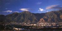
Capital
Merida.
Location
Region of you Walk them.
Limits
North: Trujillo and Zulia.
South: Barinas and Táchira.
This: Barinas.
West: Zulia and Táchira.
Surface
11 300 km2.
Percentage of the national territory
1,23%. it is the tenth fifth entity with bigger
surface of the country.
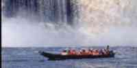
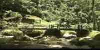
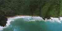
TOURISM
It possesses three natural monuments: Lagoon of
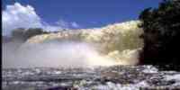
Urao, in Lagunillas. Chorrera The González,
in the Sierra of The Breech, with an it escarps
of flaw traveled by the waters of the Gulch of
The González that lower forming fallen of water
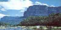
or chorreras. Plateau of The Galley, close
of Tovar; it is a medium mountain with a plane
summit. In the capital is the House
Juan Félix Sánchez, where they exhibit the
local artists' works and they carry out shows
musical. Several museums: Garden Aquarius,
Museum of Beekeeping, of Colonial Art, of Art
Modern and the Museum Mariano Picón Salas. The
cable car of Merida, the highest and I release
of the one
world; in the Pico Espejo 4 765 m of height
reaches. In Sidings it is the Monument to the
Crazy Luz Caraballo and the pick The eagle, as
well as the National Observatory of Plain of the
Cluster, the
Lagoon of Mucubají and the Black Lagoon. The
thermal waters of The Walls are in Dancers
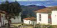
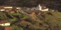
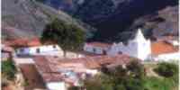
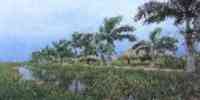
and the Park of The Chaplaincy. In Public land,
the Venezuela of Antier, and in Mucuchíes they
are Those
Eaves, both are towns created to show how one
lived in the country several decades
behind. Juan Félix Sánchez Chapel is in San
Rafael of Mucuchíes. In Sacred Domingo
it is the Truchicultura The Baho.
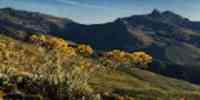
Geography
Relief
The serranías contrasts with the interior
valleys and with the flat lands. Two big lines
they stand out in the mountainous relief: the
Sierra of The Breech or of the North and the
Sierra Nevada. The
Sierra Nevada constitutes the dominant nucleus
and you/he/she gathers the biggest altitudes in
the country, with those
picks: Bolivar (5 007 m.s.n.m.), Humboldt (4 942
m.s.n.m.), Bonpland (4 883 m.s.n.m.), The
Shell (4 922 m.s.n.m.), The León (4 740
m.s.n.m.) and The Bull (4 755 m.s.n.m). In the
Sierra of
The Breech highlights the picks: Bread of Sugar
(4 620 m.s.n.m.) and The eagle (4 048 m.s.n.m.)
In
the mountainous sector the floors are quite
uniform in spite of the topography. They are of
little
depth, very stony and with scarce presence of
organic matter. Where those
slopes are less marked there are floors of
variable thickness and with better conditions
for their use. Only in the valley landscapes
floors are given with conditions
favorable for agricultural activities. In the
piedemonte they spread being of loamy texture,
with
scarce permeability and little depth. Those of
plain are those of more agricultural potential.
Climate
The climatic types go from the tropical one in
the plain, to the type moor in the more
mountains
high, and from the semi-arid one in sectors like
Lagunillas, to the very humid one tropical in
those
cloudy slopes of the basins stocking and high of
the river Caparo, prevailing inside this
tipología the humid climates that cover near
90% of the surface of the state. The
temperature in the entity registers very marked
differences due to the characteristics of the
one
mountainous relief. In Palmarito, beside the
lake of Maracaibo, the stocking is of 27 ºC and
for
above the 4 000 m.s.n.m. it reaches inferior
values to 0 ºC. The precipitations oscillate,
according to the area, between 700 mm and annual
1 800 mm.
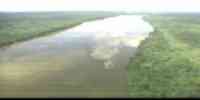
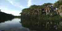
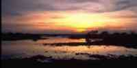
Hydrography
Two slopes exist: that of the Caribbean through
the lake of Maracaibo and that of the Atlantic,
for those
waters that you/they go to the Orinoco. In the
first one it highlights the basin of the Chama.
In her, as well as in those basins that drenan to the south of the lake,
lagoons are presented formed by effects of those
glaciers located in the Andean summits. They
highlight the lagoons of Mucubají, Quarter
note, Green,
Urao and Sacred Christ. In the state it is
generated near 10% of the waters that take place
to the one
north of the Orinoco, which are slippery through
the rivers Chama, Sacred Domingo, Motatán,
Torondoy, Capable, Tucaní, Uribante, Caparo,
Canals, Bumbún and Socopó, courses that drenan
toward the southeast coast of the lake of
Maracaibo and the high western plains.
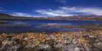
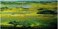
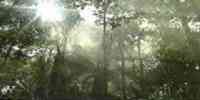
Vegetation
goes from forests rainy macrotérmicas to
vegetation moorland (gramineous and frailejón).
They are almost given the entirety of the Areas
of Life that, according to Holdridge, they
happen in Venezuela. Those
forest resources that are still located in this
landscape are formed by species like:
cedar, cumin, jabillo, mijao, saisai, ceiba and
yokel.
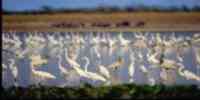
Fauna
They highlight mammals like the bear frontino or
of glasses (only representative of the bears in
South America), the coatí or Andean guache and
the Andean rabipelado or lighthouse. Ave like
the condor, the one hummingbird chops sword, the crest eagle and the
torrent duck. Amphibians as the frog
transparent and the Andean salamander. Among the
reptiles it can make an appointment the false
choral.
Mineral resources
It has the main discovered phosphate locations
up to now in Venezuela,
besides significant concentrations of lead,
zinc, copper and silver in complex, as well as
mica, berilio, litio and another series of non
metallic minerals, among those that highlight
the clays and those
calcareous.
Population
The population is of 570 215 hab according to
the XII General Census of Population and Housing
1990, of
which 47,7% resides in the metropolitan area of
Merida. This populational development him
it places in the decimotercer place with regard
to the national total, being their density of
54,5
Hab/km2. the populational dynamics indicates
that the municipalities with more concentration
of
population is: Liberator (31,32%), Alberto
Adriani (13,15%) and Campo Elías (10,29%);
there you
concentrates 54,76% of the population
estadal, being located in them the two more
cities
important: Merida whose character of student
city has exercised influence in its rhythm of
growth and The Vigía that it acts as second
significance center in populational matter
and functional.
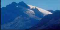
NATIONAL PARKS
It has four national parks: Sierra Nevada, among
the states Merida and Barinas, are
the only place of the country where snowed
summits are existed the whole year. Sierra of
The Breech, to the one
north of Merida. Moors Battalion-the Quarter
note, in the limits of Merida and Táchira. I
cover -
Caparo that occupies part of the states Merida,
Táchira and Barinas.
Economic ACTIVITY
They highlight in order of importance: the
agriculture, the activities of services
associated to the
University of you Walk Them and to the regional
and national government, the tourism, the cattle
raising and the
agroindustry. It is the first producing of
celery, potato, cauliflower, lettuce, carrot,
garlic, beet
and cabbage of the country. Also squatter the
second place in the pea production and cambur.
In
smaller scale is cultivated: caraota, cocoa,
yucca, banana, coffee and tomato. In the cattle
sector,
it highlights in cattle raising of bovine
(meats), swinish and birds. They are five
industries
forest of aserrío. The fishing activity has
acquired great importance through the
cultivation
of the trout in rivers, lagoons and gulches. The
marine fishing potential is restricted to the
denominated continental fishing, represented by
10 km of coast in the sector suroriental of the
one
lake of Maracaibo. The present industries in the
entity are fundamentally: products
nutritious, dresses and domestic utensils. The
tourist sector had great relevance, when being
endowed with certain infrastructure.
TRADITIONS
Among so many traditions merideñas, the Boy's
Paradura highlights that is carried out among
the 1º of
January and February 2. The party is associated
to the Christmas and to the manger. In their
version more
well-known, the ceremony begins when to the
house where is the manger, you
they present musicians and rezanderos and an or
two couples of godfathers are chosen. The
musicians
they interpret popular pieces and to a sign of
the owner of the house beginning is given to the
ritual. They are sung
verses dedicated to the Sacred Boy, candles are
distributed and a procession begins in the one
that is taken out to
to walk the Boy, well-known as having Calmed of
the Boy. Then is carried out the Boy's
Kiss, to the one that him
the Boy's Stop, or Paradura continues that it
happens when the image is lifted by those
godfathers amid songs that celebrate the one
that has been put in foot. You concludes with
one
eat. Some variants exist, as the Robbery and
Search of the Lost Boy, in the one that one
person steals the image, you/he/she takes it to
another manger, you/he/she notifies the place
where she is, and those house owners go in procession, accompanied by
musicians and singers, to look for it. The
simulation of the discovery generates a din that
finishes with the return the figure to its place
original.


 Eco-Portal
Wildlife Venezuela
Eco-Portal
Wildlife Venezuela 