DELTA
AMACURO State
Geopolitical division
The Delta like political-administrative entity,
it was created in 1884. It took the name of
Territory
Federal Delta. In 1893 it passed to be part of
the state Bolivar. In 1901 it recovers their
autonomy,
with the name of Territory Federal Delta
Amacuro. In 1991 is given state category.
You
it divides in four municipalities and veintiún
parishes.
MAP VIAL
The troncal 15 is the most important road that
unites Tucupita with Shaker, Maturín and
Barrack.
The communication is carried out, fundamentally,
through the marine and air transport. Those
populations of more relevance are, besides the
capital: Curiapo, The Horqueta, Flints,
Piacoa and Santa Catalina.
Basic DATA
Capital
Tucupita.
Location
Region of Guayana.
Limits
North: Gulf of it Gave birth to and Océano Atlántico.
South: Bolivar.
This: Ocean Atlantic.
West: Monagas.
Surface
40 200 km2.
Percentage of the national territory
4,39%. it is the seventh entity with bigger
surface of the country.
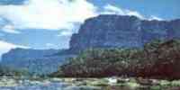
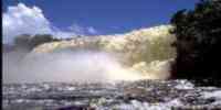
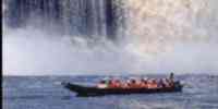
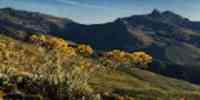
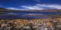
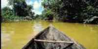
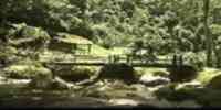
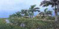
TOURISM
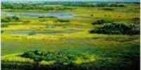
Here one of the biggest deltas in the world is,
conformed for more than 70
ramifications of rivers, pipes and channels that
you/they are born in the Orinoco and they pour
their waters in the one
Ocean Atlantic. The adventure tourism has
charged peak in the last years. To travel in
boat
by the Orinoco, and to admire the majestuosidad
of the flora and of the fauna they are the more
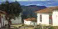
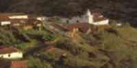
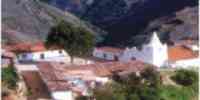
activities frequent of the visitors. In Tucupita one can
enjoy the Spa San Salvador, the
marries Indigenous and two churches: the
Divine Shepherdess's Cathedral and that of San
José of Tucupita. In Curiapo the indigenous population of the waraos
is, with crafts characteristic of this ethnos.
In Sacred Catalina the streams of Sacoroco and in
Piacoa, the Isla Tórtola.
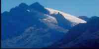
Geography
Geology
Two geologic formations exist: that of the
mountainous system of the Shield of Guayana, of
origin precámbrico, located to the south of the
main bed of the river Orinoco, and the Delta of
the Orinoco, formed in the pleistoceno and in the holoceno,
to the north of the main bed of the Orinoco. In
the area mountainous, denominated Sierra of Imataca,
there are rocks of the algonquino (it was
archaic). The region deltaic or fluvial plain of recent geologic
origin is formed by clay and slime that it to begin in the plioceno (end was third),
continuing in the pleistoceno and holoceno
(quaternary) until our days. Oil locations have
been located whose formation you
it should to marine sedimentations of the
mioceno.
Relief
In the south of the deltaic area it is given a
system of hills and surfaces disectadas that
form
it leaves of the complex of Imataca. The
mountainous topography offers certain protection
of those
floods. The islands of the superior delta are
subjected to big fluctuations of the level of
the waters for influence of the régime
biestacional of the Orinoco. The other form of
the relief is the one Delta in yes that doesn't have elevations,
except for some cones of mud. When being crossed
for one net of courses of water, they conform a sinnúmero
of islands whose floors remain flooded.
In the deltaic fan they are common the
formations of islands of scarce elevation; these
together
with the fluvial and coastal plains, they are
the characteristic forms of this relief, in
union
with the tips, bars, banks of sand, swamps and
estuaries. The floors are originated for
the contributions of the river Orinoco and their
tributaries. In the sector colinoso they are of
rocky tendency and those you leave terminals they are composed by recent
silts. The agricultural potential is minimum, because the floors have little fertility, with
acidity problems and loamy texture.
Climate
According to the classification of Köeppen, the
savanna climate prevails (Aw), in the coast, and
the climate tropical monzónico (Ami) in the most
continental area. The annual half temperature is
of 26 °C, being the maxim of 31 °C and the minimum of
20,6 °C. The temperature is high the whole
year. Those annual precipitations oscillate between 1 000
and 2 000 mm.
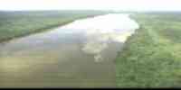
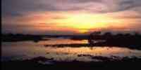
Hydrography
It is characterized by the courses of water of
the pipes and arms of the river Orinoco, of
which you/they highlight the pipes: Mánamo, Macareo, Capure, Flints,
Cocuina, Argauao, Aragüito, Sacupana, Merejina, and the Big rivers and Amacuro; that
they converge in the Océano Atlántico and they
generate one complex fluvial net and of marshy islands where
big lagoons are located.
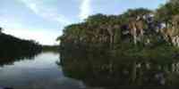
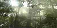
Vegetation
Four vegetable formations exist: forest that is
part of the Forest Reservation of
Imataca; forest, a tropical mantel always green,
with great variety of species; savanna,
dominated by different herbaceous species; and
the estuary, with prevalence of swamps and
some palmares. The aquatic vegetation that
highlights is the iris of water or bora.
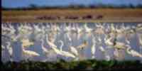
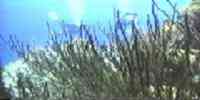
Fauna
Each one of the ecosystems has an immense
variety of species. Inside those
mammals: manatí, picure deltano and water
giant's dog. Ave: real duck, blue guacamaya and
yellow, dwarf guacamaya, swamp sparrow hawk and
the swamp cuckoo. Reptiles: different
turtle species and the small lizard deltona.
Amphibians: great variety of frogs and common
toad.
Mineral resources
The existence of alluvium gold, quartz, asphalt
has been verified, bauxite, iron, mercury,
sulfurate, it upsets and petroleum.
Population
The population is of 84 564 hab, being placed in
the twentieth third place according to the XII
Census General of Population and Housing 1990. The
populational density is of 2,3 hab/km2, that
that it indicates an uninhabited geographical space.
As for the population's evolution it is observed
that even when the absolute population has grown
starting from 1941, the percentage with regard
to the one country has diminished. On the other hand, the
indigenous communities have been emigrating
toward Monagas, escaping from the process of salinización
of the waters, product of the closing of the
pipe Mánamo. With regard to the space distribution,
it is observed that the municipality Tucupita
(with 76,33%) it is the center of the activities. In
the rest indigenous communities prevail. There
is
three big human groups culturally
diferenciables: the waraos (the most important),
those
Araucanian and the caribeses. Great percentage
of the Creoles comes from Margarita island.
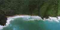
NATIONAL PARKS
It has a single national park: Delta of the
Orinoco (Mariusa) that occupies a surface of
331 000 hectares exactly in the center of the
delta of the river Orinoco, where the biggest
river of
Venezuela meets with the Océano Atlántico.
Economic ACTIVITY
The most excellent economic activities are the
agricultural ones, the fishing ones and those of
type
traditional and forest of extractive type of
hard, soft wood and span. The items
agricultural more important they are: corn,
yucca, banana, rice, cocoa, coconut and
pineapple. In the sector cattle it highlights the breeding of bovine,
bovine livestock and bufalino. The timber
production of wood in rola locates it in the fifth place of
the national total. The fishing potential has
represented one of the basic activities of
maintenance. The dominant species
they belong to the fluvial ecosystem: bagre,
lebranche, flat, bass, coporo and shrimp. These
species, except bagre and coporo, have full
identification with the mangroves. The four
more important fishing ports are: Tucupita,
Flints, Curiapo and Mysterious Island.
TRADITIONS
In the riverbanks of the rivers and pipes of the
Delta of the Orinoco settles the town
warao,
heirs of a rich wealth of cultural expressions
among those that highlight their oral tradition,
their sizes in wood and, in particular way,
their cestería. In their original expressions,
the
cestería had a double significance. First,
because they were indispensable for all the
practical activities. And, in second place, for
their spiritual implications associated to the
it disciplines and the concentration, since the
continuous manipulation of the fiber converts
the artisan in a chamán. The matter prevails of its cestería
it is the bark of the shaft of shivers.
The diversity of you form and ways of production allow to find
mapires of great size in form of
bell and of complex and slow elaboration
(humuta); sebucanes used to squeeze the one
poison of the yucca (ahuruba); handsome, species
of trays called bihi; sieves or manares;
moroki, infantile maracas; trunks or covered
baskets (foroforo), used by the chamán for
to keep the sacred matters; and fans to vivify
the fire, to turn the rod cakes of
moriche or yuruma, or even to complete spiritual
functions.


 Eco-Portal
Wildlife Venezuela
Eco-Portal
Wildlife Venezuela 