ANZOÁTEGUI
Geopolitical division
Anzoátegui belonged, to final of the XVIII century, to the County
of Cumaná. It was territory
independent starting from 1864, until the Constitution of 1881
believes the state of East.
In 1899 the Congress annuls the division of 1881 and the twenty
states of the Federation arise
Venezuelan. In 1909 she/he acquires the political physiognomy of
state. The entity is divided in
eighteen municipalities.
MAP VIAL
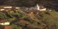
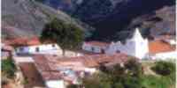
The sustained development of this area has originated the growth
of its towns,
becoming, most of them, in important cities. Among them we have:
Anaco,
Aragua of Barcelona, Cantaura, Trumpets, The Tiger, Pariaguán, Píritu,
Port The Cruz, San
I took, Santa Rosa and Soledad.
Basic DATA
Capital
Barcelona.
Location
Nor-oriental region.
Limits
North: Caribbean Sea.
South: Bolivar.
This: Sucre and Monagas.
West: Guárico and Miranda.
Surface
43 300 km2
Percentage of the national territory
4,7%. sixth entity with bigger surface of the country.
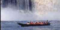
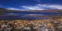
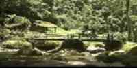
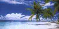
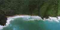
TOURISM
Their wide coastal area transforms it into an attractive pole for
the tourism. The beaches of Boca Uchire, Trumpets, The Hatillo and
Puerto Píritu attract for their vast extension and their strong
surf.
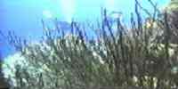
While in the islands of Mochima, the tranquility and transparency
of the sea they call the
attention of those who look for to discover the submarine fauna.
In Puerto Píritu they offer pieces
handmade characteristic of the region. In this town they can take
the peñeros that take to those
isles, where virgin beaches are still conserved. The night
activity of Port The Cruz is
very rich. Restaurants of the most diverse gastronomic tendencies
and discos for those
more varied likes take to the body to enjoy the party until the
dawn. In Dairies the Center Commercial bigger Square is, with
stores and attractions for big and boys. The Walk Columbus is
another reference forced for those that want to feel the flavor of
this state. Not very further on The High of Santa Faith, an
area of replete mountain of surprises are. Those that Esparta
travels by lorry to the New state, they should take in Port The
Cruz the ferry that it will drive them until Tip of Stones.
Beaches, islands, rivers and natural bays are to the reach of all
in the state Anzoátegui.
Geography
Geology
The geologic basements correspond to the eras third and quaternary
that are in its
majority of sedimentary origin. The first ones appear in the
mountains, represented for
loams, conglomerate, gritty, shales, calcareous and limonitas,
manifested in the formations
Quiamare, San Antonio and Querecual (Grupo Guayuta). as well as in
the system of hills,
where they are shales and calcareous clays or loams with less
extensive blooming of
gritty and not consolidated sands, corresponding to the formations
Chaguaramas,
Freites, The Stones and Quiamare. Means of ablation exist where
they are presented abundant
iron concretions, gravels and cuarcita songs belonging to the
Formación Freites. A
60% of the surface of the entity covers it the geologic basement
of the Formación Mesa of
quaternary age, not conformed by sandy materials consolidated. Of
the same era,
although more recent, they are the silts deposited by the river
Orinoco and the other rivers in those
fence, as well as the alluvial deposits and marines of the coastal
plain. The floors, are
alluvial but impoverished, not very capable for the development of
agricultural activities to great
it climbs, excepting some lands in the proximities of the rivers
and plains that present
better conditions for their use. Among them they highlight the
floors of the valleys of the one
Neverí and basins of the Unare, it Fakes and those of the Table
of Guanipa.
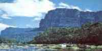
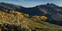
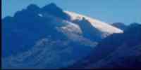
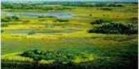
Relief
More than 90% of the state it is of plane and wavy lands that form
landscapes of Tables. The
Solid of the Turimiquire and the terminal section of the Serranía
of the Interior they are the only sectors mountainous. To the
northwest she/he is the basin of the river Unare, with a relief of
low hills.
Another important landscape is the extensive flood fringe beside
the river Orinoco. The heights
they oscillate between 0 and 2 485 m.s.n.m. in the pick Peony, but
the lands prevail with heights
smaller to 300 m.s.n.m.
Climate
The annual half temperature is located between 25° and 27°
Celsius. The climate is characterized for
to present high temperatures the whole year, with an average of
26,7 °C. The high evaporation and
the constant winds of the northeast (trade) precipitations that
oscillate between 700 and 1 take place
annual 400 mm, being able to classify, according to Köeppen, as
savanna climate (Aw).
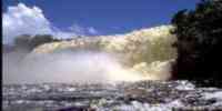
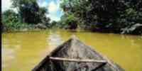
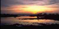
Hydrography
It is conformed by rivers with variable flow during the
whole year. Those of more importance
they are: Uchire, Unare and Neverí that end in the slope of the
Caribbean. Besides the rivers
Zuata, Pao, Caris, Tiger and Guanipa that Orinoco ends in the
river (slope of the Atlantic).
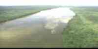
One of the alternating uses to the superficial resources
constitutes it the waters
underground located in the interior part of the Serranía of the
Turimiquire, among the rivers
Orchards and Neverí. The state has a system of reservoirs
dedicated mainly
to the control of floods and the storage of water for the urban
supply and of
watering. The most representative lagoons are: Píritu and Unare.
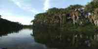
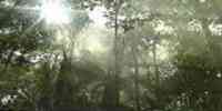
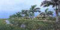
Vegetation
The vegetable covering is very varied, prevailing the vegetation
natural boscosa and those
forest plantations. The center and south is conformed by gallery
forests, located it
long of important courses of water, also forests semideciduos and
morichales in big
extensions of savannas. The use of the forest resources is
conditioned for
their potential first floor, although they highlight: olive tree,
araguaney, ceiba, cereipo, cují, jobo and she/he will see.
It presents good conditions for secondary forest products,
conservation ends and
protection. However, from 1975 they are carried out with success
plantations to open field
of pine and eucalyptus whose production is dedicated to satisfy
the future demand of pulp of
paper.
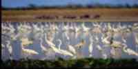
Fauna
An important number of species of mammals belonging to 30
families exists, of those
which 28 present cynegetic and economic interest; the most
important are: cachicamo,
chigüire, weasel, báquiro, deer, rabipelado, rabbit, fox, bear
melero, puma, manatí and
otter, these last ones in extinction danger. The representative
birds are: partridge, dove
sabanera and caricare encrestado. Among the reptiles it highlights
the bell of Uracoa. The sea is
rich in fito and zooplancton, what contributes to increase the
importance of the wealth
fishing. To the marine fishing it is necessary to add the existent
potential in the bodies of water,
among them the lagoons of Unare and Píritu, where species are
plentiful like: lebranche, tuna, flat,
pargo, mere, corocoro and shrimp.
Mineral resources
The fundamental energy resources are petroleum and gas. A high
potential exists of
petroleum weighed in the Oil Strip of the Orinoco and a
reservation of gas associated to the
production of the raw one, near to 25 million cubic feet. Among
the mining resources you
they count: calcareous, gritty, sands and clays. Another key
resource is the salt that she/he is formed among Píritu and
Chacopata.
Population
According to the XII General Census of Population and Housing 1990
is the eighth state more town of the one national territory, with
a population of 859 758 inhabitants. It possesses a density of
21,3
Hab/km2. the main urban centers are: Barcelona, Port The Cruz, The
Tiger, Anaco, San
José of Guanipa, Cantaura, Pariaguán, Guanta and Aragua of
Barcelona. The growth of the
population presents a fluctuating tendency, intimately related
with the activity
economic predominant. Until the decade of 1920 the populational
growth was very slow,
because the natality and the mortality were very high, ending up
presenting a rate of
growth negative between 1891 and 1920. Starting from 1926 a
recovery takes place when
the rate of inhabitants reached its maximum value in 1950 with 5%.
In the last decades the one
growth is had desacelerado, until reaching in 1990 a value of
2,6%. In what refers
to the population's distribution 58,1% concentrates on the
municipalities Bolivar (28,31%),
Sotillo (18,81%), and Simón Rodríguez (10,98%), due to the port
activities,
administrative, assistance, tourist, commercial and oil that there
are developed.
NATIONAL PARKS
It only has a national park: Mochima, which is located in the
region nor -
oriental of the country, in the states Anzoátegui and Sucre,
exactly among Port The Cruz and
Cumaná. It was the second national park decreed in the country.
Economic ACTIVITY
It is characterized by the prevalence of the oil and agricultural
activities. However, they are had
installed industries like: self-driven, materials for the
construction, derived of the petroleum,
agroindustry; and on the other hand tourist, commercial activities
have been developed and
financial.
The state participates in the production of hydrocarbons. In
Anaco-Aragua of Barcelona and The
Tiger the activities are relative to the extractive phase, while
the industrial activities
of refinement they are carried out in Port The Cruz and San
Asleep. In Anzoátegui the one is located
Complex Cryogenic of José.
The main cultivated items are: corn, cotton, cane, sorghum,
coffee, cocoa, cambur, roots
and tubers. It is the second producing of peanut of the country
and the first one in soya.
An use of forest resources is given, specially wooden in rola. As
soon as
to the cattle raising, it is the third producing of birds. While
in the fishing they highlight: tuna, flat,
machuelo, tahalí, shrimp, lobster, squid and octopus. The
development of the state has been centered
in the coastal strip. The anarchical growth has deteriorated the
environmental quality,
being evidenced problems of atmospheric contamination, I
deteriorate of the landscape, pollution of
you dilute, proliferation of drains of garbage and other toxic
residuals. The derived problems
of physical-natural processes magnified by the action antrópica
they have accelerated the process
erosivo of the basin of the Unare and the quick sedimentation of
the lagoons of Unare and Píritu.
TRADITIONS
The pole is a song characteristic of Spain that is interpreted in
the oriental states of the country.
It possesses a melody of eight compasses created freely by the
singer. Sometimes two
men are alternated to interpret it.
Among the communities of the Table of Guanipa they are signs of
the ethnos kariña. Them
they conserve among their traditions the party of the akaatompo, a
ritual in memory to the deceaseds,
because it exists the belief that the 2 and 3 of November the
deads return to visit to their
family who prepare meetings with music, songs and dances to
receive them. Those
participants, accompanied by cuatros and guitars (originally it
was made with flutes of
cane) they dance intertwined by the waist, with turns and
movements toward before and back.
But the dance that better it defines the culture kariña it is the
Mare-mare that is executed to take place the meeting of the
families or to mark the end of the mourning for a dead. The dance
is accompanied with drum music and maracas, to which has been
added the four. The choreography, formed for two lines of dancers,
she/he suggests a snake that advances and she/he goes back in
threatening attitude for then to be wound and to be uncoiled.


 Eco-Portal
Wildlife Venezuela
Eco-Portal
Wildlife Venezuela 